Hadenfeld geodata
Hadenfeld (Schleswig-Holstein) is a seat of a fourth-order administrative division; located in Germany in Europe/Berlin (GMT+2) time zone. With population of 105 people, there are 10820 cities with bigger population in this country. Compared to other cities in Germany, 93.1% of cities are located further ↓South; 58.5% of cities are located further →East and 90.9% of cities have higher elevation than Hadenfeld. Note1


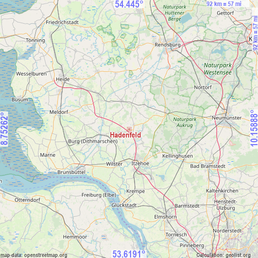
Hadenfeld GPS coordinates[2]
54° 2' 2.76" North, 9° 27' 20.7" East
| Map corner | latitude | longitude |
|---|---|---|
| Upper-left | 54.445°, | 8.75262° |
| Center: | 54.0341°, | 9.45575° |
| Lower-right: | 53.6191°, | 10.15888° |
| Map W x H: | 91.8×91.8 km | = 57×57mi |
| max Lat: | 55.01917° ⇑6.9% North |
| Hadenfeld: | 54.0341° |
| min Lat: | ⇓93.1% South 47.40724° |
| min Long | Hadenfeld | max Long |
| 5.92978° | 9.45575° | 14.98853° |
| W 41.5%⇐ | ⇒58.5% E |
Elevation
Elevation of Hadenfeld is 19 m = 62 ft, and this is 230.1 m = 755 ft below average elevation for this country.
| Max E: |
1256 m = 4121 ft | 90.9% |
| Avg. | 249.1 m = 817 ft | |
| Hadenfeld | 19 m = 62 ft | |
Min E: |
-5 m = -16 ft | 9.1% |
See also: Germany elevation on elevation.city.
Geographical zone
Hadenfeld is located in North temperate zone (between Tropic of Cancer and the Arctic Circle). Distance of this North polar circle is 1393.1 km =865.6 mi to North.| Distance of | km | miles | from Hadenfeld |
|---|---|---|---|
| North Pole | 3999 | 2484.9 | to North |
| Arctic Circle | 1393.1 | 865.6 | to North |
| Tropic Cancer | 3402.1 | 2114 | to South |
| Equator | 6008 | 3733.2 | to South |


Nearby cities:
15 places around Hadenfeld: (largest is in red/bold)
• Aasbüttel
3.9 km =2.4 mi,  337°
337°
• Agethorst
2.1 km =1.3 mi,  218°
218°
• Bokelrehm
4.6 km =2.9 mi,  275°
275°
• Bokhorst
5.1 km =3.2 mi,  314°
314°
• Christinenthal
5.4 km =3.4 mi,  70°
70°
• Drage
5.3 km =3.3 mi,  128°
128°
• Kaaks
5 km =3.1 mi,  169°
169°
• Kaisborstel
2.8 km =1.7 mi,  143°
143°
• Looft
4.5 km =2.8 mi,  97°
97°
• Mehlbek
3.6 km =2.2 mi,  202°
202°
• Nienbüttel
2.7 km =1.7 mi,  259°
259°
• Oldenborstel
5.4 km =3.4 mi,  47°
47°
• Pöschendorf
2.2 km =1.4 mi,  80°
80°
• Schenefeld
2.5 km =1.6 mi, 45°
• Wacken
5.4 km =3.4 mi,  254°
254°
Sources, notices
• [Note1] Compared only with cities in Germany existing in our database
• [Src1] Map data: © OpenStreetMap contributors (CC-BY-SA)
• [Src2] Other city data from geonames.org with taken over terms of usage.
• [Src3] Geographical zone / Annual Mean Temperature by Robert A. Rohde @ Wikipedia
