Drage geodata
Drage (Schleswig-Holstein) is a seat of a fourth-order administrative division; located in Germany in Europe/Berlin (GMT+2) time zone. With population of 263 people, there are 10196 cities with bigger population in this country. Compared to other cities in Germany, 92.7% of cities are located further ↓South; 57.4% of cities are located further →East and 92.7% of cities have higher elevation than Drage. Note1


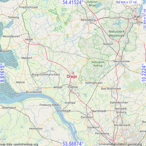
Drage GPS coordinates[2]
54° 0' 14.544" North, 9° 31' 9.372" East
| Map corner | latitude | longitude |
|---|---|---|
| Upper-left | 54.41524°, | 8.81615° |
| Center: | 54.00404°, | 9.51927° |
| Lower-right: | 53.58874°, | 10.2224° |
| Map W x H: | 91.9×91.9 km | = 57.1×57.1mi |
| max Lat: | 55.01917° ⇑7.3% North |
| Drage: | 54.00404° |
| min Lat: | ⇓92.7% South 47.40724° |
| min Long | Drage | max Long |
| 5.92978° | 9.51927° | 14.98853° |
| W 42.6%⇐ | ⇒57.4% E |
Elevation
Elevation of Drage is 14 m = 46 ft, and this is 235.1 m = 771 ft below average elevation for this country.
| Max E: |
1256 m = 4121 ft | 92.7% |
| Avg. | 249.1 m = 817 ft | |
| Drage | 14 m = 46 ft | |
Min E: |
-5 m = -16 ft | 7.3% |
See also: Germany elevation on elevation.city.
Geographical zone
Drage is located in North temperate zone (between Tropic of Cancer and the Arctic Circle). Distance of this North polar circle is 1396.5 km =867.7 mi to North.| Distance of | km | miles | from Drage |
|---|---|---|---|
| North Pole | 4002.4 | 2487 | to North |
| Arctic Circle | 1396.5 | 867.7 | to North |
| Tropic Cancer | 3398.8 | 2111.9 | to South |
| Equator | 6004.7 | 3731.1 | to South |


Nearby cities:
15 places around Drage: (largest is in red/bold)
• Agethorst
5.7 km =3.5 mi,  287°
287°
• Christinenthal
5.2 km =3.2 mi,  10°
10°
• Hadenfeld
5.3 km =3.3 mi,  308°
308°
• Hohenaspe
1.8 km =1.1 mi,  161°
161°
• Huje
6.3 km =3.9 mi,  241°
241°
• Kaaks
3.6 km =2.2 mi, 244°
• Kaisborstel
2.7 km =1.7 mi, 293°
• Looft
2.8 km =1.7 mi, 5°
• Mehlbek
5.5 km =3.4 mi,  270°
270°
• Oldendorf
6.9 km =4.3 mi,  215°
215°
• Ottenbüttel
3.8 km =2.4 mi,  195°
195°
• Peissen
6.3 km =3.9 mi,  67°
67°
• Pöschendorf
4.2 km =2.6 mi,  331°
331°
• Schenefeld
5.6 km =3.5 mi,  335°
335°
• Schlotfeld
6.7 km =4.2 mi,  142°
142°
Sources, notices
• [Note1] Compared only with cities in Germany existing in our database
• [Src1] Map data: © OpenStreetMap contributors (CC-BY-SA)
• [Src2] Other city data from geonames.org with taken over terms of usage.
• [Src3] Geographical zone / Annual Mean Temperature by Robert A. Rohde @ Wikipedia
