Lommatzsch geodata
Lommatzsch (Saxony) is a populated place; located in Germany in Europe/Berlin (GMT+2) time zone. With population of 5,999 people, there are 2463 cities with bigger population in this country. Compared to other cities in Germany, 61.4% of cities are located further ↓South; 94.4% of cities are located further ←West and 57.4% of cities have higher elevation than Lommatzsch. Note1


Lommatzsch GPS coordinates[2]
51° 11' 43.332" North, 13° 18' 33.012" East
| Map corner | latitude | longitude |
|---|---|---|
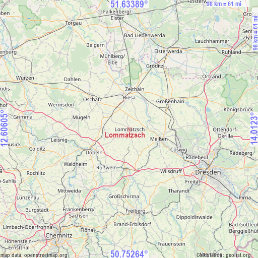
| Upper-left | 51.63389°, | 12.60605° |
| Center: | 51.19537°, | 13.30917° |
| Lower-right: | 50.75264°, | 14.0123° |
| Map W x H: | 98×98 km | = 60.9×60.9mi |
| max Lat: | 55.01917° ⇑38.6% North |
| Lommatzsch: | 51.19537° |
| min Lat: | ⇓61.4% South 47.40724° |
| min Long | Lommatzsch | max Long |
| 5.92978° | 13.30917° | 14.98853° |
| W 94.4%⇐ | ⇒5.6% E |
Elevation
Elevation of Lommatzsch is 172 m = 564 ft, and this is 77.1 m = 253 ft below average elevation for this country.
| Max E: |
1256 m = 4121 ft | 57.4% |
| Avg. | 249.1 m = 817 ft | |
| Lommatzsch | 172 m = 564 ft | |
Min E: |
-5 m = -16 ft | 42.6% |
See also: Germany elevation on elevation.city.
Geographical zone
Lommatzsch is located in North temperate zone (between Tropic of Cancer and the Arctic Circle). Distance of this North polar circle is 1708.8 km =1061.8 mi to North.| Distance of | km | miles | from Lommatzsch |
|---|---|---|---|
| North Pole | 4314.7 | 2681 | to North |
| Arctic Circle | 1708.8 | 1061.8 | to North |
| Tropic Cancer | 3086.5 | 1917.9 | to South |
| Equator | 5692.4 | 3537.1 | to South |


Nearby cities:
15 places around Lommatzsch: (largest is in red/bold)
• Döbeln
16.1 km =10 mi,  239°
239°
• Glaubitz
15.2 km =9.4 mi,  18°
18°
• Meissen
12.1 km =7.5 mi,  108°
108°
• Mochau
11.2 km =7 mi,  231°
231°
• Naundorf
15.6 km =9.7 mi,  296°
296°
• Niederau
16.6 km =10.3 mi,  96°
96°
• Niederstriegis
16.8 km =10.4 mi,  221°
221°
• Nossen
15.3 km =9.5 mi,  183°
183°
• Nünchritz
12.8 km =8 mi, 24°
• Ostrau
9.9 km =6.2 mi,  272°
272°
• Priestewitz
15.7 km =9.8 mi,  67°
67°
• Riesa
12.6 km =7.8 mi,  354°
354°
• Stauchitz
8.5 km =5.3 mi,  309°
309°
• Weißig
14.1 km =8.8 mi,  40°
40°
• Zeithain
15.5 km =9.6 mi,  7°
7°
Sources, notices
• [Note1] Compared only with cities in Germany existing in our database
• [Src1] Map data: © OpenStreetMap contributors (CC-BY-SA)
• [Src2] Other city data from geonames.org with taken over terms of usage.
• [Src3] Geographical zone / Annual Mean Temperature by Robert A. Rohde @ Wikipedia
