Naundorf geodata
Naundorf (Saxony) is a seat of a fourth-order administrative division; located in Germany in Europe/Berlin (GMT+2) time zone. With population of 2,695 people, there are 4235 cities with bigger population in this country. Compared to other cities in Germany, 62.5% of cities are located further ↓South; 93.1% of cities are located further ←West and 62.2% of cities have higher elevation than Naundorf. Note1


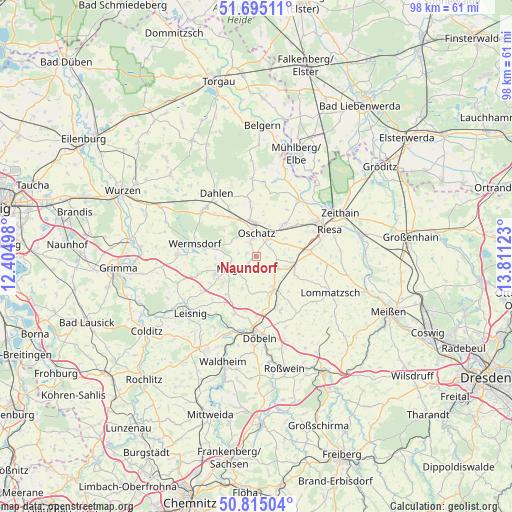
Naundorf GPS coordinates[2]
51° 15' 25.848" North, 13° 6' 29.16" East
| Map corner | latitude | longitude |
|---|---|---|
| Upper-left | 51.69511°, | 12.40498° |
| Center: | 51.25718°, | 13.1081° |
| Lower-right: | 50.81504°, | 13.81123° |
| Map W x H: | 97.9×97.9 km | = 60.8×60.8mi |
| max Lat: | 55.01917° ⇑37.5% North |
| Naundorf: | 51.25718° |
| min Lat: | ⇓62.5% South 47.40724° |
| min Long | Naundorf | max Long |
| 5.92978° | 13.1081° | 14.98853° |
| W 93.1%⇐ | ⇒6.9% E |
Elevation
Elevation of Naundorf is 137 m = 449 ft, and this is 112.1 m = 368 ft below average elevation for this country.
| Max E: |
1256 m = 4121 ft | 62.2% |
| Avg. | 249.1 m = 817 ft | |
| Naundorf | 137 m = 449 ft | |
Min E: |
-5 m = -16 ft | 37.8% |
See also: Germany elevation on elevation.city.
Geographical zone
Naundorf is located in North temperate zone (between Tropic of Cancer and the Arctic Circle). Distance of this North polar circle is 1701.9 km =1057.5 mi to North.| Distance of | km | miles | from Naundorf |
|---|---|---|---|
| North Pole | 4307.8 | 2676.7 | to North |
| Arctic Circle | 1701.9 | 1057.5 | to North |
| Tropic Cancer | 3093.3 | 1922.1 | to South |
| Equator | 5699.3 | 3541.4 | to South |


Nearby cities:
15 places around Naundorf: (largest is in red/bold)
• Bockelwitz
12.4 km =7.7 mi,  238°
238°
• Cavertitz
14.1 km =8.8 mi,  7°
7°
• Dahlen
14.2 km =8.8 mi,  327°
327°
• Döbeln
15 km =9.3 mi,  179°
179°
• Großweitzschen
11.8 km =7.3 mi,  201°
201°
• Lommatzsch
15.6 km =9.7 mi,  116°
116°
• Mochau
14.7 km =9.1 mi,  159°
159°
• Mutzschen
15.1 km =9.4 mi,  271°
271°
• Mügeln
4.9 km =3 mi, 241°
• Oschatz
4.8 km =3 mi,  1°
1°
• Ostrau
7.6 km =4.7 mi,  147°
147°
• Riesa
14 km =8.7 mi,  66°
66°
• Stauchitz
7.6 km =4.7 mi,  101°
101°
• Strehla
13.4 km =8.3 mi,  37°
37°
• Wermsdorf
11.4 km =7.1 mi,  284°
284°
Sources, notices
• [Note1] Compared only with cities in Germany existing in our database
• [Src1] Map data: © OpenStreetMap contributors (CC-BY-SA)
• [Src2] Other city data from geonames.org with taken over terms of usage.
• [Src3] Geographical zone / Annual Mean Temperature by Robert A. Rohde @ Wikipedia
