Riesa geodata
Riesa (Saxony) is a populated place; located in Germany in Europe/Berlin (GMT+2) time zone. With population of 37,156 people, there are 358 cities with bigger population in this country. Compared to other cities in Germany, 63.4% of cities are located further ↓South; 94.3% of cities are located further ←West and 66.5% of cities have higher elevation than Riesa. Note1


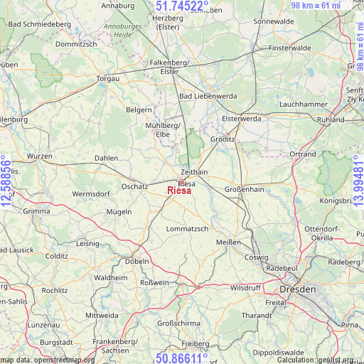
Riesa GPS coordinates[2]
51° 18' 27.972" North, 13° 17' 30.048" East
| Map corner | latitude | longitude |
|---|---|---|
| Upper-left | 51.74522°, | 12.58856° |
| Center: | 51.30777°, | 13.29168° |
| Lower-right: | 50.86611°, | 13.99481° |
| Map W x H: | 97.7×97.7 km | = 60.7×60.7mi |
| max Lat: | 55.01917° ⇑36.6% North |
| Riesa: | 51.30777° |
| min Lat: | ⇓63.4% South 47.40724° |
| min Long | Riesa | max Long |
| 5.92978° | 13.29168° | 14.98853° |
| W 94.3%⇐ | ⇒5.7% E |
Elevation
Elevation of Riesa is 111 m = 364 ft, and this is 138.1 m = 453 ft below average elevation for this country.
| Max E: |
1256 m = 4121 ft | 66.5% |
| Avg. | 249.1 m = 817 ft | |
| Riesa | 111 m = 364 ft | |
Min E: |
-5 m = -16 ft | 33.5% |
See also: Germany elevation on elevation.city.
Geographical zone
Riesa is located in North temperate zone (between Tropic of Cancer and the Arctic Circle). Distance of this North polar circle is 1696.3 km =1054 mi to North.| Distance of | km | miles | from Riesa |
|---|---|---|---|
| North Pole | 4302.2 | 2673.3 | to North |
| Arctic Circle | 1696.3 | 1054 | to North |
| Tropic Cancer | 3099 | 1925.6 | to South |
| Equator | 5704.9 | 3544.9 | to South |


Nearby cities:
15 places around Riesa: (largest is in red/bold)
• Cavertitz
13.8 km =8.6 mi,  307°
307°
• Glaubitz
6.3 km =3.9 mi,  72°
72°
• Lommatzsch
12.6 km =7.8 mi,  174°
174°
• Mühlberg
14.9 km =9.3 mi,  341°
341°
• Naundorf
14 km =8.7 mi,  246°
246°
• Nauwalde
14.8 km =9.2 mi,  33°
33°
• Nünchritz
6.6 km =4.1 mi,  97°
97°
• Oschatz
12.7 km =7.9 mi,  266°
266°
• Ostrau
14.8 km =9.2 mi,  215°
215°
• Stauchitz
8.9 km =5.5 mi, 216°
• Strehla
6.7 km =4.2 mi,  317°
317°
• Weißig
10.5 km =6.5 mi, 99°
• Wildenhain
12.9 km =8 mi,  90°
90°
• Wülknitz
10 km =6.2 mi,  48°
48°
• Zeithain
4.3 km =2.7 mi, 48°
Sources, notices
• [Note1] Compared only with cities in Germany existing in our database
• [Src1] Map data: © OpenStreetMap contributors (CC-BY-SA)
• [Src2] Other city data from geonames.org with taken over terms of usage.
• [Src3] Geographical zone / Annual Mean Temperature by Robert A. Rohde @ Wikipedia
