Mehlingen geodata
Mehlingen (Rheinland-Pfalz) is a seat of a fourth-order administrative division; located in Germany in Europe/Berlin (GMT+2) time zone. With population of 3,882 people, there are 3359 cities with bigger population in this country. Compared to other cities in Germany, 75.9% of cities are located further ↑North; 79.9% of cities are located further →East and 63.1% of cities have lower elevation than Mehlingen. Note1
Administrative division(s):
- Level 1: Rheinland-Pfalz
- Level 3: Landkreis Kaiserslautern
- Level 4: Mehlingen


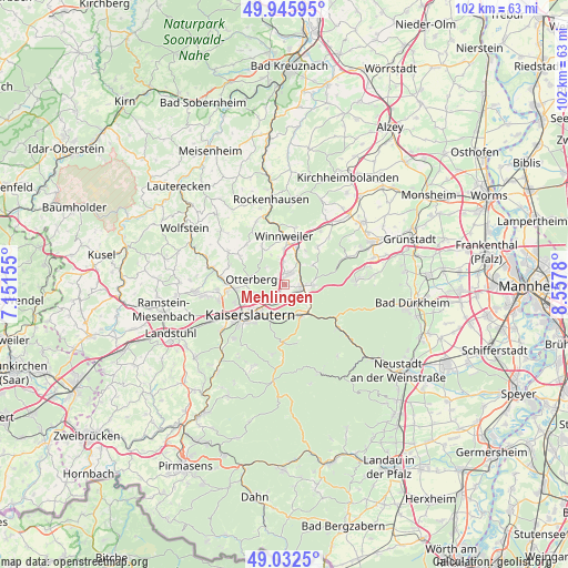
Mehlingen GPS coordinates[2]
49° 29' 28.896" North, 7° 51' 16.812" East
| Map corner | latitude | longitude |
|---|---|---|
| Upper-left | 49.94595°, | 7.15155° |
| Center: | 49.49136°, | 7.85467° |
| Lower-right: | 49.0325°, | 8.5578° |
| Map W x H: | 101.6×101.6 km | = 63.1×63.1mi |
| max Lat: | 55.01917° ⇑75.9% North |
| Mehlingen: | 49.49136° |
| min Lat: | ⇓24.1% South 47.40724° |
| min Long | Mehlingen | max Long |
| 5.92978° | 7.85467° | 14.98853° |
| W 20.1%⇐ | ⇒79.9% E |
Elevation
Elevation of Mehlingen is 309 m = 1014 ft, and this is 59.9 m = 197 ft above average elevation for this country.
| Max E: |
1256 m = 4121 ft | 36.9% |
| Mehlingen | 309 m 1014 ft | |
| Avg. | 249.1 m = 817 ft | |
Min E: |
-5 m = -16 ft | 63.1% |
See also: Germany elevation on elevation.city.
Geographical zone
Mehlingen is located in North temperate zone (between Tropic of Cancer and the Arctic Circle). Distance of this North polar circle is 1898.3 km =1179.5 mi to North.| Distance of | km | miles | from Mehlingen |
|---|---|---|---|
| North Pole | 4504.1 | 2798.7 | to North |
| Arctic Circle | 1898.3 | 1179.5 | to North |
| Tropic Cancer | 2897 | 1800.1 | to South |
| Equator | 5502.9 | 3419.3 | to South |


Nearby cities:
15 places around Mehlingen: (largest is in red/bold)
• Enkenbach-Alsenborn
3.4 km =2.1 mi,  105°
105°
• Fischbach
6.4 km =4 mi,  135°
135°
• Gonbach
7.3 km =4.5 mi,  26°
26°
• Hochspeyer
6.2 km =3.9 mi,  151°
151°
• Höringen
8.3 km =5.2 mi,  329°
329°
• Kaiserslautern
8.1 km =5 mi,  228°
228°
• Lohnsfeld
6.5 km =4 mi,  357°
357°
• Münchweiler an der Alsenz
6.8 km =4.2 mi,  17°
17°
• Neuhemsbach
5.3 km =3.3 mi,  57°
57°
• Otterbach
8.7 km =5.4 mi,  265°
265°
• Otterberg
6.3 km =3.9 mi,  281°
281°
• Sembach
2.4 km =1.5 mi, 20°
• Sippersfeld
8.6 km =5.3 mi,  41°
41°
• Wartenberg-Rohrbach
4 km =2.5 mi, 357°
• Winnweiler
8.4 km =5.2 mi, 357°
Sources, notices
• [Note1] Compared only with cities in Germany existing in our database
• [Src1] Map data: © OpenStreetMap contributors (CC-BY-SA)
• [Src2] Other city data from geonames.org with taken over terms of usage.
• [Src3] Geographical zone / Annual Mean Temperature by Robert A. Rohde @ Wikipedia
