Lobstädt geodata
Lobstädt (Saxony) is a populated place; located in Germany in Europe/Berlin (GMT+2) time zone. With population of 2,675 people, there are 4255 cities with bigger population in this country. Compared to other cities in Germany, 60.5% of cities are located further ↓South; 87.5% of cities are located further ←West and 61.5% of cities have higher elevation than Lobstädt. Note1


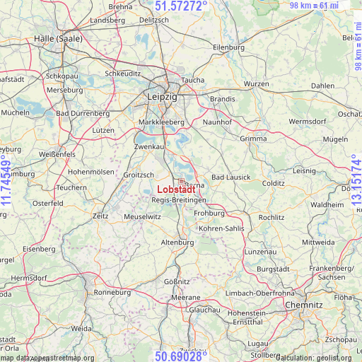
Lobstädt GPS coordinates[2]
51° 8' 0.996" North, 12° 26' 54.996" East
| Map corner | latitude | longitude |
|---|---|---|
| Upper-left | 51.57272°, | 11.74549° |
| Center: | 51.13361°, | 12.44861° |
| Lower-right: | 50.69028°, | 13.15174° |
| Map W x H: | 98.1×98.1 km | = 61×61mi |
| max Lat: | 55.01917° ⇑39.5% North |
| Lobstädt: | 51.13361° |
| min Lat: | ⇓60.5% South 47.40724° |
| min Long | Lobstädt | max Long |
| 5.92978° | 12.44861° | 14.98853° |
| W 87.5%⇐ | ⇒12.5% E |
Elevation
Elevation of Lobstädt is 142 m = 466 ft, and this is 107.1 m = 351 ft below average elevation for this country.
| Max E: |
1256 m = 4121 ft | 61.5% |
| Avg. | 249.1 m = 817 ft | |
| Lobstädt | 142 m = 466 ft | |
Min E: |
-5 m = -16 ft | 38.5% |
See also: Germany elevation on elevation.city.
Geographical zone
Lobstädt is located in North temperate zone (between Tropic of Cancer and the Arctic Circle). Distance of this North polar circle is 1715.6 km =1066 mi to North.| Distance of | km | miles | from Lobstädt |
|---|---|---|---|
| North Pole | 4321.5 | 2685.3 | to North |
| Arctic Circle | 1715.6 | 1066 | to North |
| Tropic Cancer | 3079.6 | 1913.6 | to South |
| Equator | 5685.5 | 3532.8 | to South |


Nearby cities:
15 places around Lobstädt: (largest is in red/bold)
• Borna
3.5 km =2.2 mi,  107°
107°
• Böhlen
8.6 km =5.3 mi,  329°
329°
• Deutzen
2.9 km =1.8 mi,  214°
214°
• Espenhain
6.5 km =4 mi,  18°
18°
• Fockendorf
9.4 km =5.8 mi,  172°
172°
• Frohburg
11.4 km =7.1 mi,  138°
138°
• Gerstenberg
11.5 km =7.1 mi,  183°
183°
• Haselbach
7.5 km =4.7 mi,  188°
188°
• Kitzscher
8 km =5 mi,  64°
64°
• Lucka
9 km =5.6 mi,  243°
243°
• Neukieritzsch
3.2 km =2 mi,  304°
304°
• Regis-Breitingen
5 km =3.1 mi, 188°
• Rötha
7.5 km =4.7 mi,  341°
341°
• Treben
9.6 km =6 mi, 193°
• Wintersdorf
11.1 km =6.9 mi,  216°
216°
Sources, notices
• [Note1] Compared only with cities in Germany existing in our database
• [Src1] Map data: © OpenStreetMap contributors (CC-BY-SA)
• [Src2] Other city data from geonames.org with taken over terms of usage.
• [Src3] Geographical zone / Annual Mean Temperature by Robert A. Rohde @ Wikipedia
