Borna geodata
Borna (Saxony) is a seat of a third-order administrative division; located in Germany in Europe/Berlin (GMT+2) time zone. With population of 18,806 people, there are 831 cities with bigger population in this country. Compared to other cities in Germany, 60.3% of cities are located further ↓South; 88% of cities are located further ←West and 61.5% of cities have higher elevation than Borna. Note1


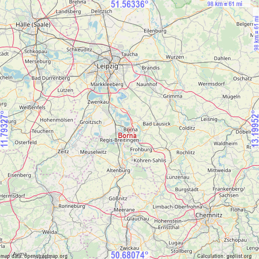
Borna GPS coordinates[2]
51° 7' 26.976" North, 12° 29' 47.004" East
| Map corner | latitude | longitude |
|---|---|---|
| Upper-left | 51.56336°, | 11.79327° |
| Center: | 51.12416°, | 12.49639° |
| Lower-right: | 50.68074°, | 13.19952° |
| Map W x H: | 98.1×98.1 km | = 61×61mi |
| max Lat: | 55.01917° ⇑39.7% North |
| Borna: | 51.12416° |
| min Lat: | ⇓60.3% South 47.40724° |
| min Long | Borna | max Long |
| 5.92978° | 12.49639° | 14.98853° |
| W 88%⇐ | ⇒12% E |
Elevation
Elevation of Borna is 142 m = 466 ft, and this is 107.1 m = 351 ft below average elevation for this country.
| Max E: |
1256 m = 4121 ft | 61.5% |
| Avg. | 249.1 m = 817 ft | |
| Borna | 142 m = 466 ft | |
Min E: |
-5 m = -16 ft | 38.5% |
See also: Germany elevation on elevation.city.
Geographical zone
Borna is located in North temperate zone (between Tropic of Cancer and the Arctic Circle). Distance of this North polar circle is 1716.7 km =1066.7 mi to North.| Distance of | km | miles | from Borna |
|---|---|---|---|
| North Pole | 4322.6 | 2685.9 | to North |
| Arctic Circle | 1716.7 | 1066.7 | to North |
| Tropic Cancer | 3078.6 | 1913 | to South |
| Equator | 5684.5 | 3532.2 | to South |


Nearby cities:
15 places around Borna: (largest is in red/bold)
• Bad Lausick
10.6 km =6.6 mi,  77°
77°
• Böhlen
11.5 km =7.1 mi,  317°
317°
• Deutzen
5.1 km =3.2 mi,  254°
254°
• Espenhain
7.3 km =4.5 mi,  350°
350°
• Fockendorf
8.5 km =5.3 mi,  194°
194°
• Frohburg
8.6 km =5.3 mi,  150°
150°
• Gerstenberg
11.2 km =7 mi,  201°
201°
• Haselbach
7.8 km =4.8 mi,  214°
214°
• Kitzscher
6 km =3.7 mi,  41°
41°
• Lobstädt
3.5 km =2.2 mi,  287°
287°
• Lucka
11.8 km =7.3 mi,  255°
255°
• Neukieritzsch
6.6 km =4.1 mi,  295°
295°
• Regis-Breitingen
5.6 km =3.5 mi,  225°
225°
• Rötha
10 km =6.2 mi,  325°
325°
• Treben
9.9 km =6.2 mi, 214°
Sources, notices
• [Note1] Compared only with cities in Germany existing in our database
• [Src1] Map data: © OpenStreetMap contributors (CC-BY-SA)
• [Src2] Other city data from geonames.org with taken over terms of usage.
• [Src3] Geographical zone / Annual Mean Temperature by Robert A. Rohde @ Wikipedia
