Linthe geodata
Linthe (Brandenburg) is a seat of a fourth-order administrative division; located in Germany in Europe/Berlin (GMT+2) time zone. With population of 945 people, there are 7366 cities with bigger population in this country. Compared to other cities in Germany, 73.5% of cities are located further ↓South; 90.6% of cities are located further ←West and 75.5% of cities have higher elevation than Linthe. Note1
Administrative division(s):
- Level 1: Brandenburg
- Level 3: Landkreis Potsdam-Mittelmark
- Level 4: Linthe


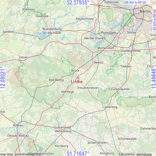
Linthe GPS coordinates[2]
52° 9' 0" North, 12° 46' 59.988" East
| Map corner | latitude | longitude |
|---|---|---|
| Upper-left | 52.57935°, | 12.08021° |
| Center: | 52.15°, | 12.78333° |
| Lower-right: | 51.71647°, | 13.48646° |
| Map W x H: | 95.9×95.9 km | = 59.6×59.6mi |
| max Lat: | 55.01917° ⇑26.5% North |
| Linthe: | 52.15° |
| min Lat: | ⇓73.5% South 47.40724° |
| min Long | Linthe | max Long |
| 5.92978° | 12.78333° | 14.98853° |
| W 90.6%⇐ | ⇒9.4% E |
Elevation
Elevation of Linthe is 61 m = 200 ft, and this is 188.1 m = 617 ft below average elevation for this country.
| Max E: |
1256 m = 4121 ft | 75.5% |
| Avg. | 249.1 m = 817 ft | |
| Linthe | 61 m = 200 ft | |
Min E: |
-5 m = -16 ft | 24.5% |
See also: Germany elevation on elevation.city.
Geographical zone
Linthe is located in North temperate zone (between Tropic of Cancer and the Arctic Circle). Distance of this North polar circle is 1602.6 km =995.8 mi to North.| Distance of | km | miles | from Linthe |
|---|---|---|---|
| North Pole | 4208.5 | 2615 | to North |
| Arctic Circle | 1602.6 | 995.8 | to North |
| Tropic Cancer | 3192.6 | 1983.8 | to South |
| Equator | 5798.5 | 3603 | to South |


Nearby cities:
15 places around Linthe: (largest is in red/bold)
• Bad Belzig
13 km =8.1 mi,  266°
266°
• Beelitz
16.1 km =10 mi,  52°
52°
• Borkheide
8.7 km =5.4 mi,  31°
31°
• Borkwalde
11.6 km =7.2 mi,  17°
17°
• Boßdorf
19.1 km =11.9 mi,  200°
200°
• Brück
5.4 km =3.4 mi,  349°
349°
• Fichtenwalde
16 km =9.9 mi, 25°
• Golzow
18.8 km =11.7 mi,  318°
318°
• Kloster Lehnin
19.1 km =11.9 mi, 351°
• Kropstädt
20.9 km =13 mi,  187°
187°
• Michendorf
24.8 km =15.4 mi,  42°
42°
• Niedergörsdorf
23.5 km =14.6 mi,  143°
143°
• Niemegk
10.6 km =6.6 mi,  217°
217°
• Treuenbrietzen
8.4 km =5.2 mi,  133°
133°
• Wiesenburg
22.7 km =14.1 mi,  260°
260°
Sources, notices
• [Note1] Compared only with cities in Germany existing in our database
• [Src1] Map data: © OpenStreetMap contributors (CC-BY-SA)
• [Src2] Other city data from geonames.org with taken over terms of usage.
• [Src3] Geographical zone / Annual Mean Temperature by Robert A. Rohde @ Wikipedia
