Kloster Lehnin geodata
Kloster Lehnin (Brandenburg) is a populated place(s); located in Germany in Europe/Berlin (GMT+2) time zone. With population of 10,669 people, there are 1552 cities with bigger population in this country. Compared to other cities in Germany, 75.4% of cities are located further ↓South; 90.2% of cities are located further ←West and 83.7% of cities have higher elevation than Kloster Lehnin. Note1
Administrative division(s):
- Level 1: Brandenburg
- Level 3: Landkreis Potsdam-Mittelmark
- Level 4: Kloster Lehnin


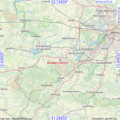
Kloster Lehnin GPS coordinates[2]
52° 19' 13.404" North, 12° 44' 35.52" East
| Map corner | latitude | longitude |
|---|---|---|
| Upper-left | 52.74809°, | 12.04008° |
| Center: | 52.32039°, | 12.7432° |
| Lower-right: | 51.88852°, | 13.44633° |
| Map W x H: | 95.6×95.6 km | = 59.4×59.4mi |
| max Lat: | 55.01917° ⇑24.6% North |
| Kloster Lehnin: | 52.32039° |
| min Lat: | ⇓75.4% South 47.40724° |
| min Long | Kloster Lehnin | max Long |
| 5.92978° | 12.7432° | 14.98853° |
| W 90.2%⇐ | ⇒9.8% E |
Elevation
Elevation of Kloster Lehnin is 38 m = 125 ft, and this is 211.1 m = 693 ft below average elevation for this country.
| Max E: |
1256 m = 4121 ft | 83.7% |
| Avg. | 249.1 m = 817 ft | |
| Kloster Lehnin | 38 m = 125 ft | |
Min E: |
-5 m = -16 ft | 16.3% |
See also: Germany elevation on elevation.city.
Geographical zone
Kloster Lehnin is located in North temperate zone (between Tropic of Cancer and the Arctic Circle). Distance of this North polar circle is 1583.7 km =984.1 mi to North.| Distance of | km | miles | from Kloster Lehnin |
|---|---|---|---|
| North Pole | 4189.6 | 2603.3 | to North |
| Arctic Circle | 1583.7 | 984.1 | to North |
| Tropic Cancer | 3211.6 | 1995.6 | to South |
| Equator | 5817.5 | 3614.8 | to South |


Nearby cities:
15 places around Kloster Lehnin: (largest is in red/bold)
• Beelitz
18 km =11.2 mi,  120°
120°
• Borkheide
13.6 km =8.5 mi,  147°
147°
• Borkwalde
9.9 km =6.2 mi,  141°
141°
• Brandenburg an der Havel
16.9 km =10.5 mi,  309°
309°
• Brück
13.8 km =8.6 mi,  172°
172°
• Fichtenwalde
10.5 km =6.5 mi, 115°
• Golzow
10.9 km =6.8 mi,  243°
243°
• Groß Kreutz
9.5 km =5.9 mi,  15°
15°
• Ketzin
18.9 km =11.7 mi, 21°
• Linthe
19.1 km =11.9 mi, 171°
• Michendorf
19.5 km =12.1 mi,  92°
92°
• Roskow
17 km =10.6 mi,  354°
354°
• Wenzlow
20.1 km =12.5 mi,  263°
263°
• Werder
14.5 km =9 mi,  63°
63°
• Wollin
19.2 km =11.9 mi, 257°
Sources, notices
• [Note1] Compared only with cities in Germany existing in our database
• [Src1] Map data: © OpenStreetMap contributors (CC-BY-SA)
• [Src2] Other city data from geonames.org with taken over terms of usage.
• [Src3] Geographical zone / Annual Mean Temperature by Robert A. Rohde @ Wikipedia
