Bremen geodata
Bremen is a seat of a first-order administrative division; located in Germany in Europe/Berlin (GMT+2) time zone. With population of 546,501 people, there are 9 cities with bigger population in this country. Compared to other cities in Germany, 82.2% of cities are located further ↓South; 67.8% of cities are located further →East and 91.2% of cities have higher elevation than Bremen. Note1


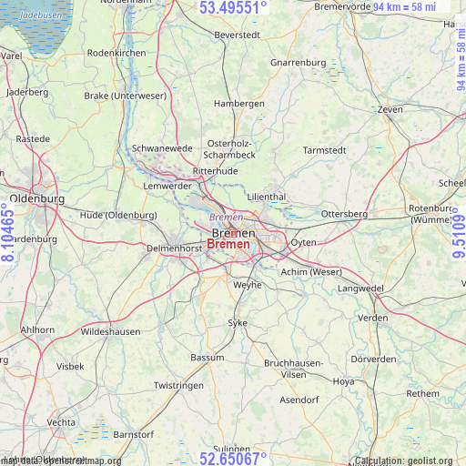
Bremen GPS coordinates[2]
53° 4' 30.576" North, 8° 48' 27.972" East
| Map corner | latitude | longitude |
|---|---|---|
| Upper-left | 53.49551°, | 8.10465° |
| Center: | 53.07516°, | 8.80777° |
| Lower-right: | 52.65067°, | 9.5109° |
| Map W x H: | 93.9×93.9 km | = 58.3×58.3mi |
| max Lat: | 55.01917° ⇑17.8% North |
| Bremen: | 53.07516° |
| min Lat: | ⇓82.2% South 47.40724° |
| min Long | Bremen | max Long |
| 5.92978° | 8.80777° | 14.98853° |
| W 32.2%⇐ | ⇒67.8% E |
Elevation
Elevation of Bremen is 18 m = 59 ft, and this is 231.1 m = 758 ft below average elevation for this country.
| Max E: |
1256 m = 4121 ft | 91.2% |
| Avg. | 249.1 m = 817 ft | |
| Bremen | 18 m = 59 ft | |
Min E: |
-5 m = -16 ft | 8.8% |
See also: Bremen elevation on elevation.city.
Geographical zone
Bremen is located in North temperate zone (between Tropic of Cancer and the Arctic Circle). Distance of this North polar circle is 1499.8 km =931.9 mi to North.| Distance of | km | miles | from Bremen |
|---|---|---|---|
| North Pole | 4105.7 | 2551.2 | to North |
| Arctic Circle | 1499.8 | 931.9 | to North |
| Tropic Cancer | 3295.5 | 2047.7 | to South |
| Equator | 5901.4 | 3667 | to South |


Nearby cities:
15 places around Bremen: (largest is in red/bold)
• Achim
16.1 km =10 mi,  114°
114°
• Burglesum
12.8 km =8 mi,  321°
321°
• Delmenhorst
12.1 km =7.5 mi,  257°
257°
• Grasberg
16.8 km =10.4 mi,  44°
44°
• Groß Ippener
17.6 km =10.9 mi,  226°
226°
• Kirchseelte
16.2 km =10.1 mi,  210°
210°
• Lemwerder
16.3 km =10.1 mi,  308°
308°
• Lilienthal
9.8 km =6.1 mi, 40°
• Osterholz-Scharmbeck
16.9 km =10.5 mi,  357°
357°
• Oyten
14.2 km =8.8 mi,  101°
101°
• Riede
15.4 km =9.6 mi,  141°
141°
• Ritterhude
12.9 km =8 mi,  338°
338°
• Stuhr
6 km =3.7 mi,  219°
219°
• Vegesack
16.3 km =10.1 mi, 308°
• Worpswede
17.8 km =11.1 mi,  28°
28°
In other languages:
- In Spanish: Bremen, Brema
- In France: Brême
- In Italian: Brema
- In Russian: Бремен
- In Chinese: 不来梅
Sources, notices
• [Note1] Compared only with cities in Germany existing in our database
• [Src1] Map data: © OpenStreetMap contributors (CC-BY-SA)
• [Src2] Other city data from geonames.org with taken over terms of usage.
• [Src3] Geographical zone / Annual Mean Temperature by Robert A. Rohde @ Wikipedia
