Burglesum geodata
Burglesum (Bremen) is a section of populated place; located in Germany in Europe/Berlin (GMT+2) time zone. With population of 33,000 people, there are 410 cities with bigger population in this country. Compared to other cities in Germany, 82.6% of cities are located further ↓South; 69.2% of cities are located further →East and 95.2% of cities have higher elevation than Burglesum. Note1


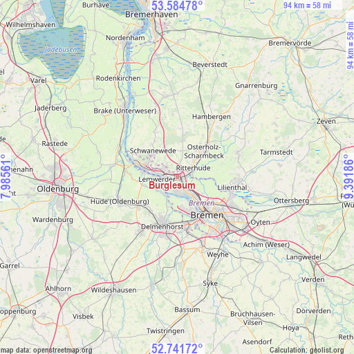
Burglesum GPS coordinates[2]
53° 9' 55.152" North, 8° 41' 19.428" East
| Map corner | latitude | longitude |
|---|---|---|
| Upper-left | 53.58478°, | 7.98561° |
| Center: | 53.16532°, | 8.68873° |
| Lower-right: | 52.74172°, | 9.39186° |
| Map W x H: | 93.7×93.7 km | = 58.2×58.2mi |
| max Lat: | 55.01917° ⇑17.4% North |
| Burglesum: | 53.16532° |
| min Lat: | ⇓82.6% South 47.40724° |
| min Long | Burglesum | max Long |
| 5.92978° | 8.68873° | 14.98853° |
| W 30.8%⇐ | ⇒69.2% E |
Elevation
Elevation of Burglesum is 8 m = 26 ft, and this is 241.1 m = 791 ft below average elevation for this country.
| Max E: |
1256 m = 4121 ft | 95.2% |
| Avg. | 249.1 m = 817 ft | |
| Burglesum | 8 m = 26 ft | |
Min E: |
-5 m = -16 ft | 4.8% |
See also: Germany elevation on elevation.city.
Geographical zone
Burglesum is located in North temperate zone (between Tropic of Cancer and the Arctic Circle). Distance of this North polar circle is 1489.7 km =925.7 mi to North.| Distance of | km | miles | from Burglesum |
|---|---|---|---|
| North Pole | 4095.6 | 2544.9 | to North |
| Arctic Circle | 1489.7 | 925.7 | to North |
| Tropic Cancer | 3305.5 | 2053.9 | to South |
| Equator | 5911.4 | 3673.2 | to South |


Nearby cities:
15 places around Burglesum: (largest is in red/bold)
• Bremen
12.8 km =8 mi,  141°
141°
• Delmenhorst
13.3 km =8.3 mi,  196°
196°
• Elsfleth
17.4 km =10.8 mi,  297°
297°
• Hude
16.4 km =10.2 mi,  246°
246°
• Lemwerder
4.8 km =3 mi,  271°
271°
• Lilienthal
14.5 km =9 mi,  100°
100°
• Neuenkirchen
13.1 km =8.1 mi, 304°
• Osterholz-Scharmbeck
9.9 km =6.2 mi,  45°
45°
• Ritterhude
3.7 km =2.3 mi,  57°
57°
• Schwanewede
9.6 km =6 mi,  321°
321°
• Stuhr
15.2 km =9.4 mi,  164°
164°
• Uthlede
17.8 km =11.1 mi,  335°
335°
• Vegesack
4.8 km =3 mi, 271°
• Worpswede
17.3 km =10.7 mi,  70°
70°
• Wulsbüttel
16.9 km =10.5 mi,  355°
355°
Sources, notices
• [Note1] Compared only with cities in Germany existing in our database
• [Src1] Map data: © OpenStreetMap contributors (CC-BY-SA)
• [Src2] Other city data from geonames.org with taken over terms of usage.
• [Src3] Geographical zone / Annual Mean Temperature by Robert A. Rohde @ Wikipedia
