Tessin geodata
Tessin (Mecklenburg-Vorpommern) is a populated place; located in Germany in Europe/Berlin (GMT+2) time zone. With population of 4,212 people, there are 3171 cities with bigger population in this country. Compared to other cities in Germany, 93% of cities are located further ↓South; 87.7% of cities are located further ←West and 92.3% of cities have higher elevation than Tessin. Note1
Administrative division(s):
- Level 1: Mecklenburg-Vorpommern
- Level 3: Landkreis Rostock
- Level 4: Tessin


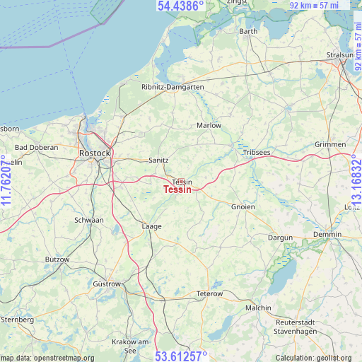
Tessin GPS coordinates[2]
54° 1' 39.504" North, 12° 27' 54.684" East
| Map corner | latitude | longitude |
|---|---|---|
| Upper-left | 54.4386°, | 11.76207° |
| Center: | 54.02764°, | 12.46519° |
| Lower-right: | 53.61257°, | 13.16832° |
| Map W x H: | 91.8×91.8 km | = 57×57mi |
| max Lat: | 55.01917° ⇑7% North |
| Tessin: | 54.02764° |
| min Lat: | ⇓93% South 47.40724° |
| min Long | Tessin | max Long |
| 5.92978° | 12.46519° | 14.98853° |
| W 87.7%⇐ | ⇒12.3% E |
Elevation
Elevation of Tessin is 15 m = 49 ft, and this is 234.1 m = 768 ft below average elevation for this country.
| Max E: |
1256 m = 4121 ft | 92.3% |
| Avg. | 249.1 m = 817 ft | |
| Tessin | 15 m = 49 ft | |
Min E: |
-5 m = -16 ft | 7.7% |
See also: Germany elevation on elevation.city.
Geographical zone
Tessin is located in North temperate zone (between Tropic of Cancer and the Arctic Circle). Distance of this North polar circle is 1393.9 km =866.1 mi to North.| Distance of | km | miles | from Tessin |
|---|---|---|---|
| North Pole | 3999.8 | 2485.4 | to North |
| Arctic Circle | 1393.9 | 866.1 | to North |
| Tropic Cancer | 3401.4 | 2113.5 | to South |
| Equator | 6007.3 | 3732.8 | to South |


Nearby cities:
15 places around Tessin: (largest is in red/bold)
• Bad Sülze
15.7 km =9.8 mi,  54°
54°
• Behren-Lübchin
13 km =8.1 mi,  89°
89°
• Broderstorf
14.4 km =8.9 mi,  294°
294°
• Cammin
8.1 km =5 mi,  239°
239°
• Dolgen
15.6 km =9.7 mi, 238°
• Dummerstorf
15.5 km =9.6 mi,  264°
264°
• Laage
13.7 km =8.5 mi,  214°
214°
• Lieblingshof
8.9 km =5.5 mi,  271°
271°
• Marlow
15.7 km =9.8 mi,  26°
26°
• Prisannewitz
16.7 km =10.4 mi,  253°
253°
• Selpin
4.5 km =2.8 mi,  153°
153°
• Thelkow
6.2 km =3.9 mi,  81°
81°
• Thulendorf
13 km =8.1 mi,  305°
305°
• Walkendorf
10.1 km =6.3 mi, 146°
• Wardow
11.4 km =7.1 mi,  199°
199°
Sources, notices
• [Note1] Compared only with cities in Germany existing in our database
• [Src1] Map data: © OpenStreetMap contributors (CC-BY-SA)
• [Src2] Other city data from geonames.org with taken over terms of usage.
• [Src3] Geographical zone / Annual Mean Temperature by Robert A. Rohde @ Wikipedia
