Leverkusen geodata
Leverkusen (North Rhine-Westphalia) is a seat of a third-order administrative division; located in Germany in Europe/Berlin (GMT+2) time zone. With population of 162,738 people, there are 58 cities with bigger population in this country. Compared to other cities in Germany, 58.6% of cities are located further ↓South; 93.5% of cities are located further →East and 78.3% of cities have higher elevation than Leverkusen. Note1
Administrative division(s):
- Level 1: North Rhine-Westphalia
- Level 2: Regierungsbezirk Köln
- Level 3: Kreisfreie Stadt Leverkusen
- Level 4: Leverkusen


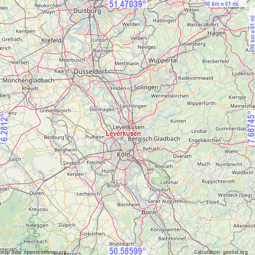
Leverkusen GPS coordinates[2]
51° 1' 49.08" North, 6° 59' 3.552" East
| Map corner | latitude | longitude |
|---|---|---|
| Upper-left | 51.47039°, | 6.2812° |
| Center: | 51.0303°, | 6.98432° |
| Lower-right: | 50.58599°, | 7.68745° |
| Map W x H: | 98.3×98.3 km | = 61.1×61.1mi |
| max Lat: | 55.01917° ⇑41.4% North |
| Leverkusen: | 51.0303° |
| min Lat: | ⇓58.6% South 47.40724° |
| min Long | Leverkusen | max Long |
| 5.92978° | 6.98432° | 14.98853° |
| W 6.5%⇐ | ⇒93.5% E |
Elevation
Elevation of Leverkusen is 52 m = 171 ft, and this is 197.1 m = 647 ft below average elevation for this country.
| Max E: |
1256 m = 4121 ft | 78.3% |
| Avg. | 249.1 m = 817 ft | |
| Leverkusen | 52 m = 171 ft | |
Min E: |
-5 m = -16 ft | 21.7% |
See also: Leverkusen elevation on elevation.city.
Geographical zone
Leverkusen is located in North temperate zone (between Tropic of Cancer and the Arctic Circle). Distance of this North polar circle is 1727.1 km =1073.2 mi to North.| Distance of | km | miles | from Leverkusen |
|---|---|---|---|
| North Pole | 4333 | 2692.4 | to North |
| Arctic Circle | 1727.1 | 1073.2 | to North |
| Tropic Cancer | 3068.1 | 1906.4 | to South |
| Equator | 5674 | 3525.7 | to South |


Nearby cities:
15 places around Leverkusen: (largest is in red/bold)
• Bilderstoeckchen
7.7 km =4.8 mi,  209°
209°
• Buchforst
9 km =5.6 mi,  170°
170°
• Buchheim
9.1 km =5.7 mi,  163°
163°
• Langenfeld
9 km =5.6 mi,  343°
343°
• Leichlingen
8.8 km =5.5 mi,  15°
15°
• Mengenich
10 km =6.2 mi,  234°
234°
• Monheim am Rhein
9.4 km =5.8 mi,  316°
316°
• Mülheim
7.2 km =4.5 mi, 169°
• Neuehrenfeld
8.8 km =5.5 mi,  202°
202°
• Neustadt/Nord
9.4 km =5.8 mi, 195°
• Nippes
7.5 km =4.7 mi, 196°
• Odenthal
9.3 km =5.8 mi,  87°
87°
• Opladen
4.5 km =2.8 mi, 17°
• Ossendorf
8.6 km =5.3 mi,  219°
219°
• Riehl
7.1 km =4.4 mi,  184°
184°
Sources, notices
• [Note1] Compared only with cities in Germany existing in our database
• [Src1] Map data: © OpenStreetMap contributors (CC-BY-SA)
• [Src2] Other city data from geonames.org with taken over terms of usage.
• [Src3] Geographical zone / Annual Mean Temperature by Robert A. Rohde @ Wikipedia
