Opladen geodata
Opladen (North Rhine-Westphalia) is a populated place; located in Germany in Europe/Berlin (GMT+2) time zone. With population of 23,000 people, there are 647 cities with bigger population in this country. Compared to other cities in Germany, 59.4% of cities are located further ↓South; 93.3% of cities are located further →East and 77.3% of cities have higher elevation than Opladen. Note1
Administrative division(s):
- Level 1: North Rhine-Westphalia
- Level 2: Regierungsbezirk Köln
- Level 3: Kreisfreie Stadt Leverkusen
- Level 4: Leverkusen


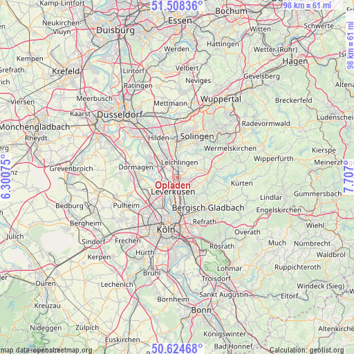
Opladen GPS coordinates[2]
51° 4' 7.068" North, 7° 0' 13.932" East
| Map corner | latitude | longitude |
|---|---|---|
| Upper-left | 51.50836°, | 6.30075° |
| Center: | 51.06863°, | 7.00387° |
| Lower-right: | 50.62468°, | 7.707° |
| Map W x H: | 98.3×98.3 km | = 61.1×61.1mi |
| max Lat: | 55.01917° ⇑40.6% North |
| Opladen: | 51.06863° |
| min Lat: | ⇓59.4% South 47.40724° |
| min Long | Opladen | max Long |
| 5.92978° | 7.00387° | 14.98853° |
| W 6.7%⇐ | ⇒93.3% E |
Elevation
Elevation of Opladen is 55 m = 180 ft, and this is 194.1 m = 637 ft below average elevation for this country.
| Max E: |
1256 m = 4121 ft | 77.3% |
| Avg. | 249.1 m = 817 ft | |
| Opladen | 55 m = 180 ft | |
Min E: |
-5 m = -16 ft | 22.7% |
See also: Germany elevation on elevation.city.
Geographical zone
Opladen is located in North temperate zone (between Tropic of Cancer and the Arctic Circle). Distance of this North polar circle is 1722.9 km =1070.6 mi to North.| Distance of | km | miles | from Opladen |
|---|---|---|---|
| North Pole | 4328.8 | 2689.8 | to North |
| Arctic Circle | 1722.9 | 1070.6 | to North |
| Tropic Cancer | 3072.4 | 1909.1 | to South |
| Equator | 5678.3 | 3528.3 | to South |


Nearby cities:
15 places around Opladen: (largest is in red/bold)
• Bergisch Gladbach
12.9 km =8 mi,  135°
135°
• Bilderstoeckchen
12.1 km =7.5 mi,  205°
205°
• Burscheid
7.9 km =4.9 mi,  76°
76°
• Dormagen
12.4 km =7.7 mi,  284°
284°
• Hilden
12.2 km =7.6 mi,  335°
335°
• Langenfeld
5.9 km =3.7 mi,  318°
318°
• Leichlingen
4.3 km =2.7 mi,  13°
13°
• Leverkusen
4.5 km =2.8 mi,  197°
197°
• Monheim am Rhein
8.2 km =5.1 mi,  288°
288°
• Mülheim
11.4 km =7.1 mi,  180°
180°
• Nippes
12 km =7.5 mi, 197°
• Odenthal
8.8 km =5.5 mi,  116°
116°
• Ossendorf
12.9 km =8 mi, 212°
• Riehl
11.5 km =7.1 mi,  189°
189°
• Solingen
12.9 km =8 mi,  25°
25°
Sources, notices
• [Note1] Compared only with cities in Germany existing in our database
• [Src1] Map data: © OpenStreetMap contributors (CC-BY-SA)
• [Src2] Other city data from geonames.org with taken over terms of usage.
• [Src3] Geographical zone / Annual Mean Temperature by Robert A. Rohde @ Wikipedia
