Langenfeld geodata
Langenfeld (North Rhine-Westphalia) is a populated place; located in Germany in Europe/Berlin (GMT+2) time zone. With population of 59,378 people, there are 177 cities with bigger population in this country. Compared to other cities in Germany, 60% of cities are located further ↓South; 94% of cities are located further →East and 78.7% of cities have higher elevation than Langenfeld. Note1
Administrative division(s):
- Level 1: North Rhine-Westphalia
- Level 2: Düsseldorf District
- Level 3: Kreis Mettmann
- Level 4: Langenfeld (Rheinland)


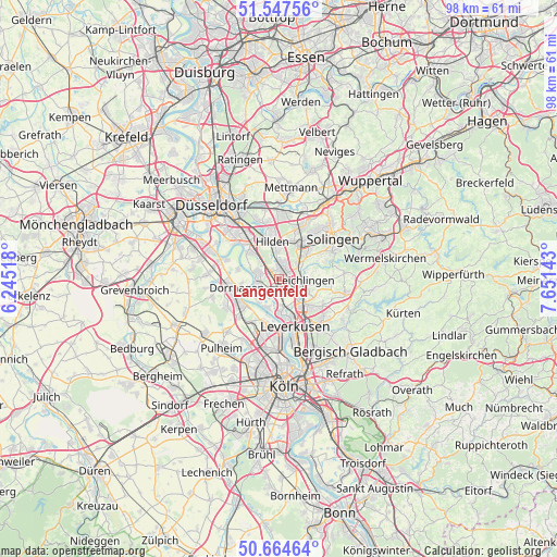
Langenfeld GPS coordinates[2]
51° 6' 29.556" North, 6° 56' 53.916" East
| Map corner | latitude | longitude |
|---|---|---|
| Upper-left | 51.54756°, | 6.24518° |
| Center: | 51.10821°, | 6.94831° |
| Lower-right: | 50.66464°, | 7.65143° |
| Map W x H: | 98.2×98.2 km | = 61×61mi |
| max Lat: | 55.01917° ⇑40% North |
| Langenfeld: | 51.10821° |
| min Lat: | ⇓60% South 47.40724° |
| min Long | Langenfeld | max Long |
| 5.92978° | 6.94831° | 14.98853° |
| W 6%⇐ | ⇒94% E |
Elevation
Elevation of Langenfeld is 51 m = 167 ft, and this is 198.1 m = 650 ft below average elevation for this country.
| Max E: |
1256 m = 4121 ft | 78.7% |
| Avg. | 249.1 m = 817 ft | |
| Langenfeld | 51 m = 167 ft | |
Min E: |
-5 m = -16 ft | 21.3% |
See also: Langenfeld elevation on elevation.city.
Geographical zone
Langenfeld is located in North temperate zone (between Tropic of Cancer and the Arctic Circle). Distance of this North polar circle is 1718.5 km =1067.8 mi to North.| Distance of | km | miles | from Langenfeld |
|---|---|---|---|
| North Pole | 4324.4 | 2687.1 | to North |
| Arctic Circle | 1718.5 | 1067.8 | to North |
| Tropic Cancer | 3076.8 | 1911.8 | to South |
| Equator | 5682.7 | 3531.1 | to South |


Nearby cities:
15 places around Langenfeld: (largest is in red/bold)
• Bilderstoeckchen
15.4 km =9.6 mi,  184°
184°
• Burscheid
11.9 km =7.4 mi,  102°
102°
• Dormagen
8.2 km =5.1 mi,  261°
261°
• Erkrath
13 km =8.1 mi,  347°
347°
• Haan
10.5 km =6.5 mi,  25°
25°
• Hilden
6.8 km =4.2 mi, 349°
• Leichlingen
4.9 km =3 mi,  92°
92°
• Leverkusen
9 km =5.6 mi,  163°
163°
• Mengenich
15.5 km =9.6 mi,  201°
201°
• Monheim am Rhein
4.3 km =2.7 mi,  244°
244°
• Odenthal
14.4 km =8.9 mi,  125°
125°
• Opladen
5.9 km =3.7 mi,  138°
138°
• Ossendorf
15.6 km =9.7 mi,  190°
190°
• Sinnersdorf
13 km =8.1 mi,  224°
224°
• Solingen
12 km =7.5 mi,  52°
52°
Sources, notices
• [Note1] Compared only with cities in Germany existing in our database
• [Src1] Map data: © OpenStreetMap contributors (CC-BY-SA)
• [Src2] Other city data from geonames.org with taken over terms of usage.
• [Src3] Geographical zone / Annual Mean Temperature by Robert A. Rohde @ Wikipedia
