Leipzig geodata
Leipzig (Saxony) is a seat of a third-order administrative division; located in Germany in Europe/Berlin (GMT+2) time zone. With population of 504,971 people, there are 11 cities with bigger population in this country. Compared to other cities in Germany, 63.8% of cities are located further ↓South; 86.6% of cities are located further ←West and 65.7% of cities have higher elevation than Leipzig. Note1


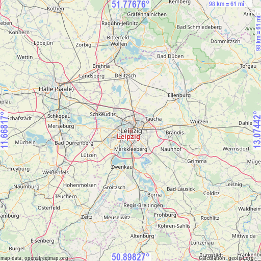
Leipzig GPS coordinates[2]
51° 20' 22.632" North, 12° 22' 16.644" East
| Map corner | latitude | longitude |
|---|---|---|
| Upper-left | 51.77676°, | 11.66817° |
| Center: | 51.33962°, | 12.37129° |
| Lower-right: | 50.89827°, | 13.07442° |
| Map W x H: | 97.7×97.7 km | = 60.7×60.7mi |
| max Lat: | 55.01917° ⇑36.2% North |
| Leipzig: | 51.33962° |
| min Lat: | ⇓63.8% South 47.40724° |
| min Long | Leipzig | max Long |
| 5.92978° | 12.37129° | 14.98853° |
| W 86.6%⇐ | ⇒13.4% E |
Elevation
Elevation of Leipzig is 116 m = 381 ft, and this is 133.1 m = 437 ft below average elevation for this country.
| Max E: |
1256 m = 4121 ft | 65.7% |
| Avg. | 249.1 m = 817 ft | |
| Leipzig | 116 m = 381 ft | |
Min E: |
-5 m = -16 ft | 34.3% |
See also: Leipzig elevation on elevation.city.
Geographical zone
Leipzig is located in North temperate zone (between Tropic of Cancer and the Arctic Circle). Distance of this North polar circle is 1692.7 km =1051.8 mi to North.| Distance of | km | miles | from Leipzig |
|---|---|---|---|
| North Pole | 4298.6 | 2671 | to North |
| Arctic Circle | 1692.7 | 1051.8 | to North |
| Tropic Cancer | 3102.5 | 1927.8 | to South |
| Equator | 5708.4 | 3547 | to South |


Nearby cities:
15 places around Leipzig: (largest is in red/bold)
• Borsdorf
11.3 km =7 mi,  84°
84°
• Böhlen
15.5 km =9.6 mi,  176°
176°
• Großlehna
14.3 km =8.9 mi,  255°
255°
• Großpösna
12.1 km =7.5 mi,  132°
132°
• Günthersdorf
13.9 km =8.6 mi,  272°
272°
• Krostitz
14.8 km =9.2 mi,  22°
22°
• Kötschlitz
14 km =8.7 mi,  277°
277°
• Markkleeberg
7.1 km =4.4 mi, 181°
• Markranstädt
11.3 km =7 mi,  247°
247°
• Rackwitz
10.5 km =6.5 mi,  4°
4°
• Schkeuditz
12.2 km =7.6 mi,  301°
301°
• Taucha
9.2 km =5.7 mi,  58°
58°
• Zschortau
15.6 km =9.7 mi,  356°
356°
• Zwenkau
13.7 km =8.5 mi,  192°
192°
• Zwochau
15.6 km =9.7 mi,  332°
332°
Sources, notices
• [Note1] Compared only with cities in Germany existing in our database
• [Src1] Map data: © OpenStreetMap contributors (CC-BY-SA)
• [Src2] Other city data from geonames.org with taken over terms of usage.
• [Src3] Geographical zone / Annual Mean Temperature by Robert A. Rohde @ Wikipedia
