Taucha geodata
Taucha (Saxony) is a populated place; located in Germany in Europe/Berlin (GMT+2) time zone. With population of 14,552 people, there are 1089 cities with bigger population in this country. Compared to other cities in Germany, 64.4% of cities are located further ↓South; 87.8% of cities are located further ←West and 63.9% of cities have higher elevation than Taucha. Note1


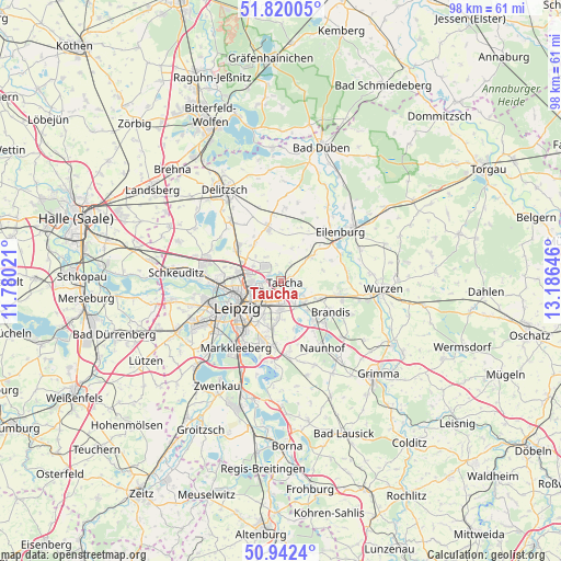
Taucha GPS coordinates[2]
51° 22' 59.988" North, 12° 28' 59.988" East
| Map corner | latitude | longitude |
|---|---|---|
| Upper-left | 51.82005°, | 11.78021° |
| Center: | 51.38333°, | 12.48333° |
| Lower-right: | 50.9424°, | 13.18646° |
| Map W x H: | 97.6×97.6 km | = 60.6×60.6mi |
| max Lat: | 55.01917° ⇑35.6% North |
| Taucha: | 51.38333° |
| min Lat: | ⇓64.4% South 47.40724° |
| min Long | Taucha | max Long |
| 5.92978° | 12.48333° | 14.98853° |
| W 87.8%⇐ | ⇒12.2% E |
Elevation
Elevation of Taucha is 127 m = 417 ft, and this is 122.1 m = 401 ft below average elevation for this country.
| Max E: |
1256 m = 4121 ft | 63.9% |
| Avg. | 249.1 m = 817 ft | |
| Taucha | 127 m = 417 ft | |
Min E: |
-5 m = -16 ft | 36.1% |
See also: Germany elevation on elevation.city.
Geographical zone
Taucha is located in North temperate zone (between Tropic of Cancer and the Arctic Circle). Distance of this North polar circle is 1687.9 km =1048.8 mi to North.| Distance of | km | miles | from Taucha |
|---|---|---|---|
| North Pole | 4293.8 | 2668 | to North |
| Arctic Circle | 1687.9 | 1048.8 | to North |
| Tropic Cancer | 3107.4 | 1930.8 | to South |
| Equator | 5713.3 | 3550.1 | to South |


Nearby cities:
15 places around Taucha: (largest is in red/bold)
• Bennewitz
16.2 km =10.1 mi,  98°
98°
• Borsdorf
5.1 km =3.2 mi,  136°
136°
• Brandis
10.3 km =6.4 mi,  120°
120°
• Eilenburg
13.4 km =8.3 mi,  50°
50°
• Großpösna
13 km =8.1 mi,  174°
174°
• Jesewitz
7.1 km =4.4 mi, 51°
• Krostitz
9 km =5.6 mi,  346°
346°
• Leipzig
9.2 km =5.7 mi,  238°
238°
• Machern
10.6 km =6.6 mi, 100°
• Markkleeberg
14.4 km =8.9 mi,  213°
213°
• Naunhof
13.8 km =8.6 mi,  148°
148°
• Rackwitz
8.9 km =5.5 mi,  308°
308°
• Thallwitz
14.9 km =9.3 mi,  68°
68°
• Zschepplin
15.3 km =9.5 mi,  31°
31°
• Zschortau
13.7 km =8.5 mi,  321°
321°
Sources, notices
• [Note1] Compared only with cities in Germany existing in our database
• [Src1] Map data: © OpenStreetMap contributors (CC-BY-SA)
• [Src2] Other city data from geonames.org with taken over terms of usage.
• [Src3] Geographical zone / Annual Mean Temperature by Robert A. Rohde @ Wikipedia
