Legde geodata
Legde (Brandenburg) is a populated place; located in Germany in Europe/Berlin (GMT+2) time zone. With population of 752 people, there are 8089 cities with bigger population in this country. Compared to other cities in Germany, 81.2% of cities are located further ↓South; 81.3% of cities are located further ←West and 88.3% of cities have higher elevation than Legde. Note1
Administrative division(s):
- Level 1: Brandenburg
- Level 3: Landkreis Prignitz
- Level 4: Legde/Quitzöbel


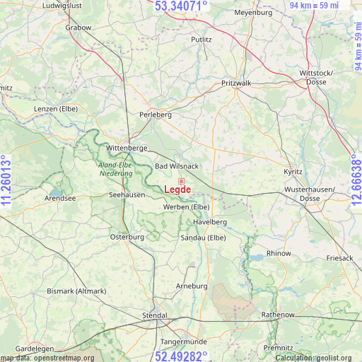
Legde GPS coordinates[2]
52° 55' 7.824" North, 11° 57' 47.7" East
| Map corner | latitude | longitude |
|---|---|---|
| Upper-left | 53.34071°, | 11.26013° |
| Center: | 52.91884°, | 11.96325° |
| Lower-right: | 52.49282°, | 12.66638° |
| Map W x H: | 94.3×94.3 km | = 58.6×58.6mi |
| max Lat: | 55.01917° ⇑18.8% North |
| Legde: | 52.91884° |
| min Lat: | ⇓81.2% South 47.40724° |
| min Long | Legde | max Long |
| 5.92978° | 11.96325° | 14.98853° |
| W 81.3%⇐ | ⇒18.7% E |
Elevation
Elevation of Legde is 26 m = 85 ft, and this is 223.1 m = 732 ft below average elevation for this country.
| Max E: |
1256 m = 4121 ft | 88.3% |
| Avg. | 249.1 m = 817 ft | |
| Legde | 26 m = 85 ft | |
Min E: |
-5 m = -16 ft | 11.7% |
See also: Germany elevation on elevation.city.
Geographical zone
Legde is located in North temperate zone (between Tropic of Cancer and the Arctic Circle). Distance of this North polar circle is 1517.2 km =942.7 mi to North.| Distance of | km | miles | from Legde |
|---|---|---|---|
| North Pole | 4123 | 2561.9 | to North |
| Arctic Circle | 1517.2 | 942.7 | to North |
| Tropic Cancer | 3278.1 | 2036.9 | to South |
| Equator | 5884 | 3656.1 | to South |


Nearby cities:
15 places around Legde: (largest is in red/bold)
• Bad Wilsnack
4.2 km =2.6 mi,  347°
347°
• Behrendorf
10.3 km =6.4 mi,  181°
181°
• Beuster
12.1 km =7.5 mi,  281°
281°
• Breese
14.2 km =8.8 mi,  309°
309°
• Havelberg
12.3 km =7.6 mi,  142°
142°
• Iden
15.8 km =9.8 mi,  192°
192°
• Königsmark
15.6 km =9.7 mi,  211°
211°
• Plattenburg
6.3 km =3.9 mi,  44°
44°
• Rühstädt
6.5 km =4 mi,  267°
267°
• Sandau
15.4 km =9.6 mi,  158°
158°
• Schönberg
10.2 km =6.3 mi,  245°
245°
• Seehausen
14.5 km =9 mi,  256°
256°
• Weisen
16.7 km =10.4 mi,  315°
315°
• Werben
6.6 km =4.1 mi,  168°
168°
• Wittenberge
17.2 km =10.7 mi,  304°
304°
Sources, notices
• [Note1] Compared only with cities in Germany existing in our database
• [Src1] Map data: © OpenStreetMap contributors (CC-BY-SA)
• [Src2] Other city data from geonames.org with taken over terms of usage.
• [Src3] Geographical zone / Annual Mean Temperature by Robert A. Rohde @ Wikipedia
