Plattenburg geodata
Plattenburg (Brandenburg) is a seat of a fourth-order administrative division; located in Germany in Europe/Berlin (GMT+2) time zone. With population of 4,049 people, there are 3269 cities with bigger population in this country. Compared to other cities in Germany, 81.5% of cities are located further ↓South; 82.2% of cities are located further ←West and 85.8% of cities have higher elevation than Plattenburg. Note1


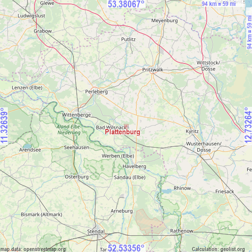
Plattenburg GPS coordinates[2]
52° 57' 33.084" North, 12° 1' 46.236" East
| Map corner | latitude | longitude |
|---|---|---|
| Upper-left | 53.38067°, | 11.32639° |
| Center: | 52.95919°, | 12.02951° |
| Lower-right: | 52.53356°, | 12.73264° |
| Map W x H: | 94.2×94.2 km | = 58.5×58.5mi |
| max Lat: | 55.01917° ⇑18.5% North |
| Plattenburg: | 52.95919° |
| min Lat: | ⇓81.5% South 47.40724° |
| min Long | Plattenburg | max Long |
| 5.92978° | 12.02951° | 14.98853° |
| W 82.2%⇐ | ⇒17.8% E |
Elevation
Elevation of Plattenburg is 33 m = 108 ft, and this is 216.1 m = 709 ft below average elevation for this country.
| Max E: |
1256 m = 4121 ft | 85.8% |
| Avg. | 249.1 m = 817 ft | |
| Plattenburg | 33 m = 108 ft | |
Min E: |
-5 m = -16 ft | 14.2% |
See also: Germany elevation on elevation.city.
Geographical zone
Plattenburg is located in North temperate zone (between Tropic of Cancer and the Arctic Circle). Distance of this North polar circle is 1512.7 km =939.9 mi to North.| Distance of | km | miles | from Plattenburg |
|---|---|---|---|
| North Pole | 4118.6 | 2559.2 | to North |
| Arctic Circle | 1512.7 | 939.9 | to North |
| Tropic Cancer | 3282.6 | 2039.7 | to South |
| Equator | 5888.5 | 3658.9 | to South |


Nearby cities:
15 places around Plattenburg: (largest is in red/bold)
• Bad Wilsnack
5.4 km =3.4 mi,  266°
266°
• Behrendorf
15.5 km =9.6 mi,  197°
197°
• Beuster
16.5 km =10.3 mi,  262°
262°
• Breddin
15.4 km =9.6 mi,  122°
122°
• Breese
16 km =9.9 mi,  286°
286°
• Groß Pankow
17.9 km =11.1 mi,  4°
4°
• Gumtow
15 km =9.3 mi,  79°
79°
• Havelberg
14.6 km =9.1 mi,  167°
167°
• Legde
6.3 km =3.9 mi,  224°
224°
• Perleberg
17.3 km =10.7 mi,  318°
318°
• Rühstädt
11.9 km =7.4 mi,  246°
246°
• Sandau
18.9 km =11.7 mi,  176°
176°
• Schönberg
16.3 km =10.1 mi,  237°
237°
• Weisen
17.8 km =11.1 mi, 294°
• Werben
11.4 km =7.1 mi, 196°
Sources, notices
• [Note1] Compared only with cities in Germany existing in our database
• [Src1] Map data: © OpenStreetMap contributors (CC-BY-SA)
• [Src2] Other city data from geonames.org with taken over terms of usage.
• [Src3] Geographical zone / Annual Mean Temperature by Robert A. Rohde @ Wikipedia
