Werben geodata
Werben (Saxony-Anhalt) is a populated place; located in Germany in Europe/Berlin (GMT+2) time zone. With population of 860 people, there are 7664 cities with bigger population in this country. Compared to other cities in Germany, 80.8% of cities are located further ↓South; 81.6% of cities are located further ←West and 87% of cities have higher elevation than Werben. Note1
Administrative division(s):
- Level 1: Saxony-Anhalt
- Level 3: Landkreis Stendal
- Level 4: Werben (Elbe)


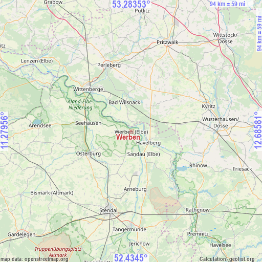
Werben GPS coordinates[2]
52° 51' 39.924" North, 11° 58' 57.648" East
| Map corner | latitude | longitude |
|---|---|---|
| Upper-left | 53.28353°, | 11.27956° |
| Center: | 52.86109°, | 11.98268° |
| Lower-right: | 52.4345°, | 12.68581° |
| Map W x H: | 94.4×94.4 km | = 58.7×58.7mi |
| max Lat: | 55.01917° ⇑19.2% North |
| Werben: | 52.86109° |
| min Lat: | ⇓80.8% South 47.40724° |
| min Long | Werben | max Long |
| 5.92978° | 11.98268° | 14.98853° |
| W 81.6%⇐ | ⇒18.4% E |
Elevation
Elevation of Werben is 30 m = 98 ft, and this is 219.1 m = 719 ft below average elevation for this country.
| Max E: |
1256 m = 4121 ft | 87% |
| Avg. | 249.1 m = 817 ft | |
| Werben | 30 m = 98 ft | |
Min E: |
-5 m = -16 ft | 13% |
See also: Germany elevation on elevation.city.
Geographical zone
Werben is located in North temperate zone (between Tropic of Cancer and the Arctic Circle). Distance of this North polar circle is 1523.6 km =946.7 mi to North.| Distance of | km | miles | from Werben |
|---|---|---|---|
| North Pole | 4129.5 | 2566 | to North |
| Arctic Circle | 1523.6 | 946.7 | to North |
| Tropic Cancer | 3271.7 | 2032.9 | to South |
| Equator | 5877.6 | 3652.2 | to South |


Nearby cities:
15 places around Werben: (largest is in red/bold)
• Bad Wilsnack
10.8 km =6.7 mi,  347°
347°
• Behrendorf
4.1 km =2.5 mi,  201°
201°
• Beuster
15.8 km =9.8 mi,  303°
303°
• Breddin
16.4 km =10.2 mi,  80°
80°
• Havelberg
7.1 km =4.4 mi,  118°
118°
• Hohenberg-Krusemark
15.3 km =9.5 mi,  188°
188°
• Iden
10.2 km =6.3 mi,  207°
207°
• Kamern
15.3 km =9.5 mi,  145°
145°
• Königsmark
11.6 km =7.2 mi,  233°
233°
• Legde
6.6 km =4.1 mi, 348°
• Plattenburg
11.4 km =7.1 mi,  16°
16°
• Rühstädt
9.9 km =6.2 mi,  308°
308°
• Sandau
9 km =5.6 mi, 151°
• Schönberg
10.8 km =6.7 mi,  281°
281°
• Seehausen
15.8 km =9.8 mi, 281°
Sources, notices
• [Note1] Compared only with cities in Germany existing in our database
• [Src1] Map data: © OpenStreetMap contributors (CC-BY-SA)
• [Src2] Other city data from geonames.org with taken over terms of usage.
• [Src3] Geographical zone / Annual Mean Temperature by Robert A. Rohde @ Wikipedia
