Regenstauf geodata
Regenstauf (Bavaria) is a populated place; located in Germany in Europe/Berlin (GMT+2) time zone. With population of 14,999 people, there are 1065 cities with bigger population in this country. Compared to other cities in Germany, 81.5% of cities are located further ↑North; 83.6% of cities are located further ←West and 69.3% of cities have lower elevation than Regenstauf. Note1
Administrative division(s):
- Level 1: Bavaria
- Level 2: Upper Palatinate
- Level 3: Landkreis Regensburg
- Level 4: Regenstauf, Markt


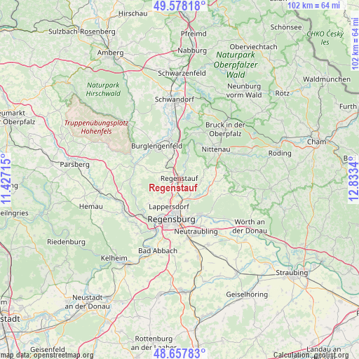
Regenstauf GPS coordinates[2]
49° 7' 12.504" North, 12° 7' 48.972" East
| Map corner | latitude | longitude |
|---|---|---|
| Upper-left | 49.57818°, | 11.42715° |
| Center: | 49.12014°, | 12.13027° |
| Lower-right: | 48.65783°, | 12.8334° |
| Map W x H: | 102.3×102.3 km | = 63.6×63.6mi |
| max Lat: | 55.01917° ⇑81.5% North |
| Regenstauf: | 49.12014° |
| min Lat: | ⇓18.5% South 47.40724° |
| min Long | Regenstauf | max Long |
| 5.92978° | 12.13027° | 14.98853° |
| W 83.6%⇐ | ⇒16.4% E |
Elevation
Elevation of Regenstauf is 353 m = 1158 ft, and this is 103.9 m = 341 ft above average elevation for this country.
| Max E: |
1256 m = 4121 ft | 30.7% |
| Regenstauf | 353 m 1158 ft | |
| Avg. | 249.1 m = 817 ft | |
Min E: |
-5 m = -16 ft | 69.3% |
See also: Germany elevation on elevation.city.
Geographical zone
Regenstauf is located in North temperate zone (between Tropic of Cancer and the Arctic Circle). Distance of this North polar circle is 1939.5 km =1205.1 mi to North.| Distance of | km | miles | from Regenstauf |
|---|---|---|---|
| North Pole | 4545.4 | 2824.4 | to North |
| Arctic Circle | 1939.5 | 1205.1 | to North |
| Tropic Cancer | 2855.7 | 1774.4 | to South |
| Equator | 5461.6 | 3393.7 | to South |


Nearby cities:
15 places around Regenstauf: (largest is in red/bold)
• Altenthann
12.6 km =7.8 mi,  100°
100°
• Bernhardswald
9.1 km =5.7 mi,  110°
110°
• Burglengenfeld
11.2 km =7 mi,  326°
326°
• Donaustauf
11.1 km =6.9 mi,  150°
150°
• Lappersdorf
8.6 km =5.3 mi,  199°
199°
• Maxhütte-Haidhof
9.3 km =5.8 mi,  342°
342°
• Nittenau
12.9 km =8 mi,  50°
50°
• Pettendorf
11.1 km =6.9 mi,  233°
233°
• Regensburg
11.9 km =7.4 mi,  190°
190°
• Reinhausen
10 km =6.2 mi, 187°
• Tegernheim
11.1 km =6.9 mi,  163°
163°
• Teublitz
11.8 km =7.3 mi, 344°
• Wenzenbach
7.1 km =4.4 mi,  134°
134°
• Wolfsegg
11.2 km =7 mi,  262°
262°
• Zeitlarn
4.8 km =3 mi, 196°
Sources, notices
• [Note1] Compared only with cities in Germany existing in our database
• [Src1] Map data: © OpenStreetMap contributors (CC-BY-SA)
• [Src2] Other city data from geonames.org with taken over terms of usage.
• [Src3] Geographical zone / Annual Mean Temperature by Robert A. Rohde @ Wikipedia
