Erbendorf geodata
Erbendorf (Bavaria) is a populated place; located in Germany in Europe/Berlin (GMT+2) time zone. With population of 5,364 people, there are 2677 cities with bigger population in this country. Compared to other cities in Germany, 68% of cities are located further ↑North; 82.4% of cities are located further ←West and 87.8% of cities have lower elevation than Erbendorf. Note1
Administrative division(s):
- Level 1: Bavaria
- Level 2: Upper Palatinate
- Level 3: Landkreis Tirschenreuth
- Level 4: Erbendorf


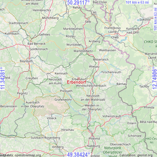
Erbendorf GPS coordinates[2]
49° 50' 23.388" North, 12° 2' 45.348" East
| Map corner | latitude | longitude |
|---|---|---|
| Upper-left | 50.29117°, | 11.34281° |
| Center: | 49.83983°, | 12.04593° |
| Lower-right: | 49.38424°, | 12.74906° |
| Map W x H: | 100.8×100.8 km | = 62.6×62.6mi |
| max Lat: | 55.01917° ⇑68% North |
| Erbendorf: | 49.83983° |
| min Lat: | ⇓32% South 47.40724° |
| min Long | Erbendorf | max Long |
| 5.92978° | 12.04593° | 14.98853° |
| W 82.4%⇐ | ⇒17.6% E |
Elevation
Elevation of Erbendorf is 492 m = 1614 ft, and this is 242.9 m = 797 ft above average elevation for this country.
| Max E: |
1256 m = 4121 ft | 12.2% |
| Erbendorf | 492 m 1614 ft | |
| Avg. | 249.1 m = 817 ft | |
Min E: |
-5 m = -16 ft | 87.8% |
See also: Germany elevation on elevation.city.
Geographical zone
Erbendorf is located in North temperate zone (between Tropic of Cancer and the Arctic Circle). Distance of this North polar circle is 1859.5 km =1155.4 mi to North.| Distance of | km | miles | from Erbendorf |
|---|---|---|---|
| North Pole | 4465.4 | 2774.7 | to North |
| Arctic Circle | 1859.5 | 1155.4 | to North |
| Tropic Cancer | 2935.8 | 1824.2 | to South |
| Equator | 5541.7 | 3443.5 | to South |


Nearby cities:
15 places around Erbendorf: (largest is in red/bold)
• Berg
7.4 km =4.6 mi,  112°
112°
• Friedenfels
6.2 km =3.9 mi,  39°
39°
• Fuchsmühl
11.7 km =7.3 mi, 37°
• Kastl
10.5 km =6.5 mi,  266°
266°
• Kemnath
11.6 km =7.2 mi,  286°
286°
• Kirchendemenreuth
7.4 km =4.6 mi,  148°
148°
• Krummennaab
3.9 km =2.4 mi,  100°
100°
• Kulmain
12.4 km =7.7 mi,  302°
302°
• Neusorg
11.8 km =7.3 mi,  331°
331°
• Parkstein
12.4 km =7.7 mi,  172°
172°
• Pressath
11 km =6.8 mi,  223°
223°
• Pullenreuth
10.9 km =6.8 mi,  342°
342°
• Trabitz
11.4 km =7.1 mi,  247°
247°
• Wiesau
12.8 km =8 mi,  53°
53°
• Windischeschenbach
9.1 km =5.7 mi,  118°
118°
Sources, notices
• [Note1] Compared only with cities in Germany existing in our database
• [Src1] Map data: © OpenStreetMap contributors (CC-BY-SA)
• [Src2] Other city data from geonames.org with taken over terms of usage.
• [Src3] Geographical zone / Annual Mean Temperature by Robert A. Rohde @ Wikipedia
