Kreuzwertheim geodata
Kreuzwertheim (Bavaria) is a populated place; located in Germany in Europe/Berlin (GMT+2) time zone. With population of 3,862 people, there are 3373 cities with bigger population in this country. Compared to other cities in Germany, 69.7% of cities are located further ↑North; 57.4% of cities are located further →East and 60.3% of cities have higher elevation than Kreuzwertheim. Note1
Administrative division(s):
- Level 1: Bavaria
- Level 2: Regierungsbezirk Unterfranken
- Level 3: Landkreis Main-Spessart
- Level 4: Kreuzwertheim, Markt


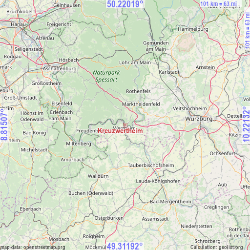
Kreuzwertheim GPS coordinates[2]
49° 46' 5.448" North, 9° 31' 5.484" East
| Map corner | latitude | longitude |
|---|---|---|
| Upper-left | 50.22019°, | 8.81507° |
| Center: | 49.76818°, | 9.51819° |
| Lower-right: | 49.31192°, | 10.22132° |
| Map W x H: | 101×101 km | = 62.8×62.8mi |
| max Lat: | 55.01917° ⇑69.7% North |
| Kreuzwertheim: | 49.76818° |
| min Lat: | ⇓30.3% South 47.40724° |
| min Long | Kreuzwertheim | max Long |
| 5.92978° | 9.51819° | 14.98853° |
| W 42.6%⇐ | ⇒57.4% E |
Elevation
Elevation of Kreuzwertheim is 150 m = 492 ft, and this is 99.1 m = 325 ft below average elevation for this country.
| Max E: |
1256 m = 4121 ft | 60.3% |
| Avg. | 249.1 m = 817 ft | |
| Kreuzwertheim | 150 m = 492 ft | |
Min E: |
-5 m = -16 ft | 39.7% |
See also: Germany elevation on elevation.city.
Geographical zone
Kreuzwertheim is located in North temperate zone (between Tropic of Cancer and the Arctic Circle). Distance of this North polar circle is 1867.5 km =1160.4 mi to North.| Distance of | km | miles | from Kreuzwertheim |
|---|---|---|---|
| North Pole | 4473.4 | 2779.6 | to North |
| Arctic Circle | 1867.5 | 1160.4 | to North |
| Tropic Cancer | 2927.8 | 1819.3 | to South |
| Equator | 5533.7 | 3438.5 | to South |


Nearby cities:
15 places around Kreuzwertheim: (largest is in red/bold)
• Altenbuch
10.7 km =6.6 mi,  308°
308°
• Bischbrunn
11.5 km =7.1 mi,  349°
349°
• Dorfprozelten
10 km =6.2 mi,  277°
277°
• Esselbach
9.7 km =6 mi,  3°
3°
• Faulbach
5.6 km =3.5 mi,  289°
289°
• Hafenlohr
12.8 km =8 mi,  28°
28°
• Hasloch
3.2 km =2 mi,  326°
326°
• Holzkirchen
11.7 km =7.3 mi,  82°
82°
• Külsheim
11 km =6.8 mi,  177°
177°
• Marktheidenfeld
10.5 km =6.5 mi,  35°
35°
• Neubrunn
11.8 km =7.3 mi,  110°
110°
• Neunkirchen
10.7 km =6.6 mi,  230°
230°
• Schollbrunn
8.4 km =5.2 mi, 332°
• Stadtprozelten
7.9 km =4.9 mi, 283°
• Wertheim
1.2 km =0.7 mi,  214°
214°
Sources, notices
• [Note1] Compared only with cities in Germany existing in our database
• [Src1] Map data: © OpenStreetMap contributors (CC-BY-SA)
• [Src2] Other city data from geonames.org with taken over terms of usage.
• [Src3] Geographical zone / Annual Mean Temperature by Robert A. Rohde @ Wikipedia
