Dorfprozelten geodata
Dorfprozelten (Bavaria) is a seat of a fourth-order administrative division; located in Germany in Europe/Berlin (GMT+2) time zone. With population of 1,911 people, there are 5189 cities with bigger population in this country. Compared to other cities in Germany, 69.5% of cities are located further ↑North; 59.6% of cities are located further →East and 61.1% of cities have higher elevation than Dorfprozelten. Note1
Administrative division(s):
- Level 1: Bavaria
- Level 2: Regierungsbezirk Unterfranken
- Level 3: Landkreis Miltenberg
- Level 4: Dorfprozelten


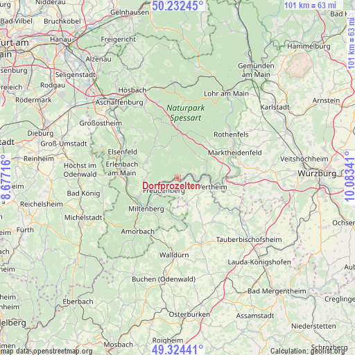
Dorfprozelten GPS coordinates[2]
49° 46' 50.016" North, 9° 22' 49.008" East
| Map corner | latitude | longitude |
|---|---|---|
| Upper-left | 50.23245°, | 8.67716° |
| Center: | 49.78056°, | 9.38028° |
| Lower-right: | 49.32441°, | 10.08341° |
| Map W x H: | 101×101 km | = 62.8×62.8mi |
| max Lat: | 55.01917° ⇑69.5% North |
| Dorfprozelten: | 49.78056° |
| min Lat: | ⇓30.5% South 47.40724° |
| min Long | Dorfprozelten | max Long |
| 5.92978° | 9.38028° | 14.98853° |
| W 40.4%⇐ | ⇒59.6% E |
Elevation
Elevation of Dorfprozelten is 145 m = 476 ft, and this is 104.1 m = 342 ft below average elevation for this country.
| Max E: |
1256 m = 4121 ft | 61.1% |
| Avg. | 249.1 m = 817 ft | |
| Dorfprozelten | 145 m = 476 ft | |
Min E: |
-5 m = -16 ft | 38.9% |
See also: Germany elevation on elevation.city.
Geographical zone
Dorfprozelten is located in North temperate zone (between Tropic of Cancer and the Arctic Circle). Distance of this North polar circle is 1866.1 km =1159.5 mi to North.| Distance of | km | miles | from Dorfprozelten |
|---|---|---|---|
| North Pole | 4472 | 2778.8 | to North |
| Arctic Circle | 1866.1 | 1159.5 | to North |
| Tropic Cancer | 2929.2 | 1820.1 | to South |
| Equator | 5535.1 | 3439.4 | to South |


Nearby cities:
15 places around Dorfprozelten: (largest is in red/bold)
• Altenbuch
5.6 km =3.5 mi,  15°
15°
• Bürgstadt
10.8 km =6.7 mi,  227°
227°
• Eichenbühl
9.1 km =5.7 mi,  203°
203°
• Eschau
9.7 km =6 mi,  296°
296°
• Faulbach
4.6 km =2.9 mi,  83°
83°
• Freudenberg
4.8 km =3 mi, 231°
• Hasloch
8.2 km =5.1 mi, 81°
• Kreuzwertheim
10 km =6.2 mi,  97°
97°
• Miltenberg
11.7 km =7.3 mi,  223°
223°
• Mönchberg
8.1 km =5 mi,  279°
279°
• Neunkirchen
8.3 km =5.2 mi,  168°
168°
• Röllbach
9.7 km =6 mi,  265°
265°
• Schollbrunn
8.5 km =5.3 mi,  44°
44°
• Stadtprozelten
2.3 km =1.4 mi, 78°
• Wertheim
9.5 km =5.9 mi, 104°
Sources, notices
• [Note1] Compared only with cities in Germany existing in our database
• [Src1] Map data: © OpenStreetMap contributors (CC-BY-SA)
• [Src2] Other city data from geonames.org with taken over terms of usage.
• [Src3] Geographical zone / Annual Mean Temperature by Robert A. Rohde @ Wikipedia
