Esselbach geodata
Esselbach (Bavaria) is a seat of a fourth-order administrative division; located in Germany in Europe/Berlin (GMT+2) time zone. With population of 2,018 people, there are 5043 cities with bigger population in this country. Compared to other cities in Germany, 67.6% of cities are located further ↑North; 57.3% of cities are located further →East and 62.9% of cities have lower elevation than Esselbach. Note1
Administrative division(s):
- Level 1: Bavaria
- Level 2: Regierungsbezirk Unterfranken
- Level 3: Landkreis Main-Spessart
- Level 4: Esselbach


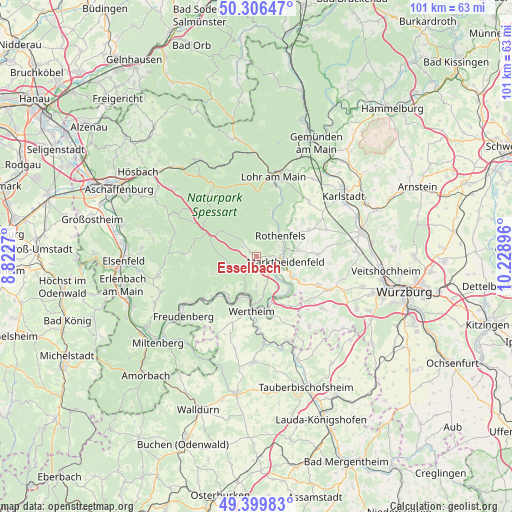
Esselbach GPS coordinates[2]
49° 51' 19.008" North, 9° 31' 32.988" East
| Map corner | latitude | longitude |
|---|---|---|
| Upper-left | 50.30647°, | 8.8227° |
| Center: | 49.85528°, | 9.52583° |
| Lower-right: | 49.39983°, | 10.22896° |
| Map W x H: | 100.8×100.8 km | = 62.6×62.6mi |
| max Lat: | 55.01917° ⇑67.6% North |
| Esselbach: | 49.85528° |
| min Lat: | ⇓32.4% South 47.40724° |
| min Long | Esselbach | max Long |
| 5.92978° | 9.52583° | 14.98853° |
| W 42.7%⇐ | ⇒57.3% E |
Elevation
Elevation of Esselbach is 308 m = 1010 ft, and this is 58.9 m = 193 ft above average elevation for this country.
| Max E: |
1256 m = 4121 ft | 37.1% |
| Esselbach | 308 m 1010 ft | |
| Avg. | 249.1 m = 817 ft | |
Min E: |
-5 m = -16 ft | 62.9% |
See also: Germany elevation on elevation.city.
Geographical zone
Esselbach is located in North temperate zone (between Tropic of Cancer and the Arctic Circle). Distance of this North polar circle is 1857.8 km =1154.4 mi to North.| Distance of | km | miles | from Esselbach |
|---|---|---|---|
| North Pole | 4463.7 | 2773.6 | to North |
| Arctic Circle | 1857.8 | 1154.4 | to North |
| Tropic Cancer | 2937.5 | 1825.3 | to South |
| Equator | 5543.4 | 3444.5 | to South |


Nearby cities:
15 places around Esselbach: (largest is in red/bold)
• Altenbuch
9.4 km =5.8 mi,  251°
251°
• Bischbrunn
3.1 km =1.9 mi,  302°
302°
• Faulbach
9.7 km =6 mi,  216°
216°
• Hafenlohr
5.7 km =3.5 mi,  73°
73°
• Hasloch
7.4 km =4.6 mi,  198°
198°
• Karbach
8.1 km =5 mi,  80°
80°
• Kreuzwertheim
9.7 km =6 mi,  183°
183°
• Marktheidenfeld
5.7 km =3.5 mi,  101°
101°
• Neustadt am Main
8.9 km =5.5 mi,  19°
19°
• Roden
8.5 km =5.3 mi,  58°
58°
• Rothenfels
6.2 km =3.9 mi,  50°
50°
• Schollbrunn
5 km =3.1 mi,  243°
243°
• Stadtprozelten
11.3 km =7 mi,  226°
226°
• Urspringen
11.6 km =7.2 mi, 63°
• Wertheim
10.8 km =6.7 mi,  186°
186°
Sources, notices
• [Note1] Compared only with cities in Germany existing in our database
• [Src1] Map data: © OpenStreetMap contributors (CC-BY-SA)
• [Src2] Other city data from geonames.org with taken over terms of usage.
• [Src3] Geographical zone / Annual Mean Temperature by Robert A. Rohde @ Wikipedia
