Marktheidenfeld geodata
Marktheidenfeld (Bavaria) is a populated place; located in Germany in Europe/Berlin (GMT+2) time zone. With population of 11,024 people, there are 1502 cities with bigger population in this country. Compared to other cities in Germany, 67.9% of cities are located further ↑North; 56.1% of cities are located further →East and 58.8% of cities have higher elevation than Marktheidenfeld. Note1
Administrative division(s):
- Level 1: Bavaria
- Level 2: Regierungsbezirk Unterfranken
- Level 3: Landkreis Main-Spessart
- Level 4: Marktheidenfeld


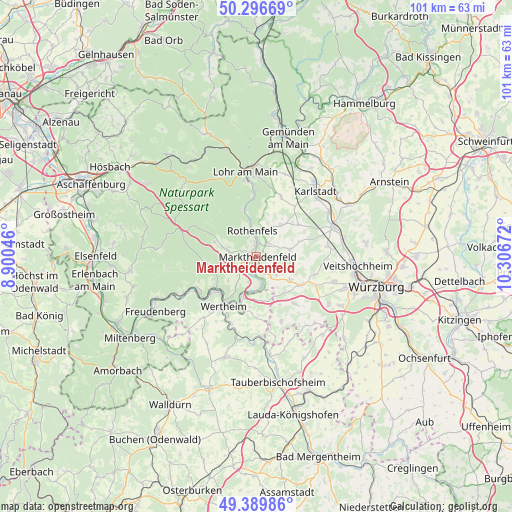
Marktheidenfeld GPS coordinates[2]
49° 50' 43.44" North, 9° 36' 12.924" East
| Map corner | latitude | longitude |
|---|---|---|
| Upper-left | 50.29669°, | 8.90046° |
| Center: | 49.8454°, | 9.60359° |
| Lower-right: | 49.38986°, | 10.30672° |
| Map W x H: | 100.8×100.8 km | = 62.6×62.6mi |
| max Lat: | 55.01917° ⇑67.9% North |
| Marktheidenfeld: | 49.8454° |
| min Lat: | ⇓32.1% South 47.40724° |
| min Long | Marktheidenfeld | max Long |
| 5.92978° | 9.60359° | 14.98853° |
| W 43.9%⇐ | ⇒56.1% E |
Elevation
Elevation of Marktheidenfeld is 162 m = 531 ft, and this is 87.1 m = 286 ft below average elevation for this country.
| Max E: |
1256 m = 4121 ft | 58.8% |
| Avg. | 249.1 m = 817 ft | |
| Marktheidenfeld | 162 m = 531 ft | |
Min E: |
-5 m = -16 ft | 41.2% |
See also: Germany elevation on elevation.city.
Geographical zone
Marktheidenfeld is located in North temperate zone (between Tropic of Cancer and the Arctic Circle). Distance of this North polar circle is 1858.9 km =1155.1 mi to North.| Distance of | km | miles | from Marktheidenfeld |
|---|---|---|---|
| North Pole | 4464.8 | 2774.3 | to North |
| Arctic Circle | 1858.9 | 1155.1 | to North |
| Tropic Cancer | 2936.4 | 1824.6 | to South |
| Equator | 5542.3 | 3443.8 | to South |


Nearby cities:
15 places around Marktheidenfeld: (largest is in red/bold)
• Birkenfeld
6.8 km =4.2 mi,  77°
77°
• Bischbrunn
8.7 km =5.4 mi,  288°
288°
• Esselbach
5.7 km =3.5 mi,  281°
281°
• Hafenlohr
2.7 km =1.7 mi,  357°
357°
• Hasloch
9.9 km =6.2 mi,  233°
233°
• Holzkirchen
9 km =5.6 mi,  142°
142°
• Karbach
3.4 km =2.1 mi,  45°
45°
• Kreuzwertheim
10.5 km =6.5 mi,  215°
215°
• Neustadt am Main
9.8 km =6.1 mi,  344°
344°
• Remlingen
8 km =5 mi,  124°
124°
• Roden
5.8 km =3.6 mi,  16°
16°
• Rothenfels
5.2 km =3.2 mi,  351°
351°
• Schollbrunn
10.1 km =6.3 mi,  263°
263°
• Uettingen
10.7 km =6.6 mi, 121°
• Urspringen
7.9 km =4.9 mi,  37°
37°
Sources, notices
• [Note1] Compared only with cities in Germany existing in our database
• [Src1] Map data: © OpenStreetMap contributors (CC-BY-SA)
• [Src2] Other city data from geonames.org with taken over terms of usage.
• [Src3] Geographical zone / Annual Mean Temperature by Robert A. Rohde @ Wikipedia
