Korweiler geodata
Korweiler (Rheinland-Pfalz) is a seat of a fourth-order administrative division; located in Germany in Europe/Berlin (GMT+2) time zone. With population of 79 people, there are 10896 cities with bigger population in this country. Compared to other cities in Germany, 61.4% of cities are located further ↑North; 88.4% of cities are located further →East and 66% of cities have lower elevation than Korweiler. Note1
Administrative division(s):
- Level 1: Rheinland-Pfalz
- Level 3: Rhein-Hunsrück-Kreis
- Level 4: Korweiler


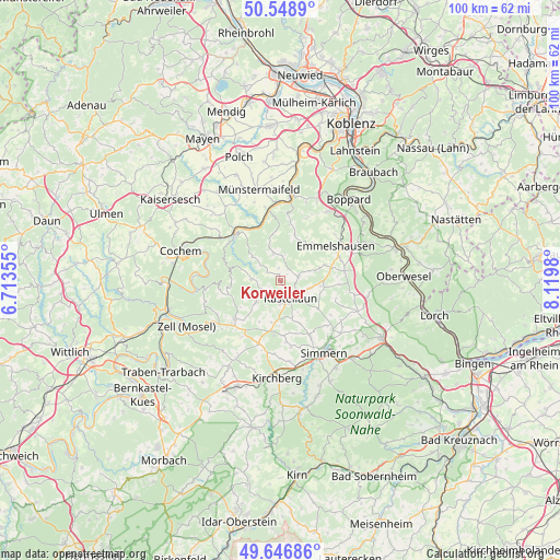
Korweiler GPS coordinates[2]
50° 6' 0" North, 7° 25' 0.012" East
| Map corner | latitude | longitude |
|---|---|---|
| Upper-left | 50.5489°, | 6.71355° |
| Center: | 50.1°, | 7.41667° |
| Lower-right: | 49.64686°, | 8.1198° |
| Map W x H: | 100.3×100.3 km | = 62.3×62.3mi |
| max Lat: | 55.01917° ⇑61.4% North |
| Korweiler: | 50.1° |
| min Lat: | ⇓38.6% South 47.40724° |
| min Long | Korweiler | max Long |
| 5.92978° | 7.41667° | 14.98853° |
| W 11.6%⇐ | ⇒88.4% E |
Elevation
Elevation of Korweiler is 328 m = 1076 ft, and this is 78.9 m = 259 ft above average elevation for this country.
| Max E: |
1256 m = 4121 ft | 34% |
| Korweiler | 328 m 1076 ft | |
| Avg. | 249.1 m = 817 ft | |
Min E: |
-5 m = -16 ft | 66% |
See also: Germany elevation on elevation.city.
Geographical zone
Korweiler is located in North temperate zone (between Tropic of Cancer and the Arctic Circle). Distance of this North polar circle is 1830.6 km =1137.5 mi to North.| Distance of | km | miles | from Korweiler |
|---|---|---|---|
| North Pole | 4436.5 | 2756.7 | to North |
| Arctic Circle | 1830.6 | 1137.5 | to North |
| Tropic Cancer | 2964.7 | 1842.2 | to South |
| Equator | 5570.6 | 3461.4 | to South |


Nearby cities:
15 places around Korweiler: (largest is in red/bold)
• Bell
4.3 km =2.7 mi,  181°
181°
• Beltheim
3.3 km =2.1 mi,  78°
78°
• Buch
3.3 km =2.1 mi,  216°
216°
• Dommershausen
5.7 km =3.5 mi,  347°
347°
• Gödenroth
5.1 km =3.2 mi,  111°
111°
• Hollnich
6 km =3.7 mi,  127°
127°
• Kastellaun
3.9 km =2.4 mi,  152°
152°
• Lahr
4.6 km =2.9 mi,  307°
307°
• Lieg
6 km =3.7 mi, 307°
• Mastershausen
6 km =3.7 mi,  232°
232°
• Mörsdorf
4.8 km =3 mi,  270°
270°
• Roth
3 km =1.9 mi, 127°
• Spesenroth
6 km =3.7 mi,  156°
156°
• Uhler
2.2 km =1.4 mi, 147°
• Zilshausen
3 km =1.9 mi, 307°
Sources, notices
• [Note1] Compared only with cities in Germany existing in our database
• [Src1] Map data: © OpenStreetMap contributors (CC-BY-SA)
• [Src2] Other city data from geonames.org with taken over terms of usage.
• [Src3] Geographical zone / Annual Mean Temperature by Robert A. Rohde @ Wikipedia
