Königshain geodata
Königshain (Saxony) is a seat of a fourth-order administrative division; located in Germany in Europe/Berlin (GMT+2) time zone. With population of 1,283 people, there are 6354 cities with bigger population in this country. Compared to other cities in Germany, 61.2% of cities are located further ↓South; 99.9% of cities are located further ←West and 52.9% of cities have lower elevation than Königshain. Note1


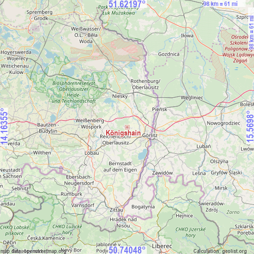
Königshain GPS coordinates[2]
51° 10' 59.988" North, 14° 52' 0.012" East
| Map corner | latitude | longitude |
|---|---|---|
| Upper-left | 51.62197°, | 14.16355° |
| Center: | 51.18333°, | 14.86667° |
| Lower-right: | 50.74048°, | 15.5698° |
| Map W x H: | 98×98 km | = 60.9×60.9mi |
| max Lat: | 55.01917° ⇑38.8% North |
| Königshain: | 51.18333° |
| min Lat: | ⇓61.2% South 47.40724° |
| min Long | Königshain | max Long |
| 5.92978° | 14.86667° | 14.98853° |
| W 99.9%⇐ | ⇒0.099999999999994% E |
Elevation
Elevation of Königshain is 246 m = 807 ft, and this is 3.1 m = 10 ft below average elevation for this country.
| Max E: |
1256 m = 4121 ft | 47.1% |
| Avg. | 249.1 m = 817 ft | |
| Königshain | 246 m = 807 ft | |
Min E: |
-5 m = -16 ft | 52.9% |
See also: Germany elevation on elevation.city.
Geographical zone
Königshain is located in North temperate zone (between Tropic of Cancer and the Arctic Circle). Distance of this North polar circle is 1710.1 km =1062.6 mi to North.| Distance of | km | miles | from Königshain |
|---|---|---|---|
| North Pole | 4316 | 2681.8 | to North |
| Arctic Circle | 1710.1 | 1062.6 | to North |
| Tropic Cancer | 3085.1 | 1917 | to South |
| Equator | 5691.1 | 3536.3 | to South |


Nearby cities:
15 places around Königshain: (largest is in red/bold)
• Bernstadt
15.4 km =9.6 mi,  190°
190°
• Görlitz
9.1 km =5.7 mi,  110°
110°
• Horka
13.2 km =8.2 mi,  10°
10°
• Kodersdorf
6.9 km =4.3 mi,  15°
15°
• Löbau
16.7 km =10.4 mi,  236°
236°
• Markersdorf
5.7 km =3.5 mi,  168°
168°
• Mücka
18.8 km =11.7 mi,  321°
321°
• Niesky
12.5 km =7.8 mi,  345°
345°
• Ostritz
19.3 km =12 mi, 166°
• Quitzdorf
13.1 km =8.1 mi,  327°
327°
• Reichenbach
6.4 km =4 mi,  223°
223°
• Rothenburg
18.2 km =11.3 mi, 22°
• Schönau-Berzdorf
13.3 km =8.3 mi, 174°
• Sohland am Rotstein
9.4 km =5.8 mi, 217°
• Weißenberg
14.6 km =9.1 mi,  275°
275°
Sources, notices
• [Note1] Compared only with cities in Germany existing in our database
• [Src1] Map data: © OpenStreetMap contributors (CC-BY-SA)
• [Src2] Other city data from geonames.org with taken over terms of usage.
• [Src3] Geographical zone / Annual Mean Temperature by Robert A. Rohde @ Wikipedia
