Quitzdorf geodata
Quitzdorf (Saxony) is a populated place; located in Germany in Europe/Berlin (GMT+2) time zone. With population of 1,702 people, there are 5507 cities with bigger population in this country. Compared to other cities in Germany, 62.9% of cities are located further ↓South; 99.8% of cities are located further ←West and 59.2% of cities have higher elevation than Quitzdorf. Note1


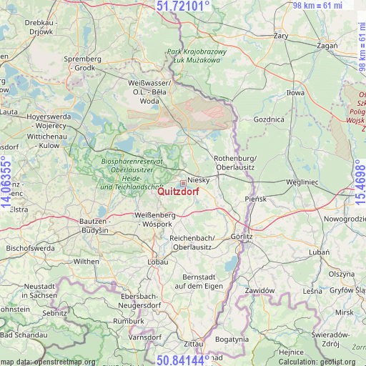
Quitzdorf GPS coordinates[2]
51° 16' 59.988" North, 14° 46' 0.012" East
| Map corner | latitude | longitude |
|---|---|---|
| Upper-left | 51.72101°, | 14.06355° |
| Center: | 51.28333°, | 14.76667° |
| Lower-right: | 50.84144°, | 15.4698° |
| Map W x H: | 97.8×97.8 km | = 60.8×60.8mi |
| max Lat: | 55.01917° ⇑37.1% North |
| Quitzdorf: | 51.28333° |
| min Lat: | ⇓62.9% South 47.40724° |
| min Long | Quitzdorf | max Long |
| 5.92978° | 14.76667° | 14.98853° |
| W 99.8%⇐ | ⇒0.2% E |
Elevation
Elevation of Quitzdorf is 159 m = 522 ft, and this is 90.1 m = 296 ft below average elevation for this country.
| Max E: |
1256 m = 4121 ft | 59.2% |
| Avg. | 249.1 m = 817 ft | |
| Quitzdorf | 159 m = 522 ft | |
Min E: |
-5 m = -16 ft | 40.8% |
See also: Germany elevation on elevation.city.
Geographical zone
Quitzdorf is located in North temperate zone (between Tropic of Cancer and the Arctic Circle). Distance of this North polar circle is 1699 km =1055.7 mi to North.| Distance of | km | miles | from Quitzdorf |
|---|---|---|---|
| North Pole | 4304.9 | 2674.9 | to North |
| Arctic Circle | 1699 | 1055.7 | to North |
| Tropic Cancer | 3096.3 | 1924 | to South |
| Equator | 5702.2 | 3543.2 | to South |


Nearby cities:
15 places around Quitzdorf: (largest is in red/bold)
• Guttau
14.5 km =9 mi,  259°
259°
• Horka
9.5 km =5.9 mi,  78°
78°
• Hähnichen
11.2 km =7 mi,  35°
35°
• Klitten
13.5 km =8.4 mi,  303°
303°
• Kodersdorf
9.9 km =6.2 mi,  117°
117°
• Königshain
13.1 km =8.1 mi,  147°
147°
• Malschwitz
17.8 km =11.1 mi,  253°
253°
• Markersdorf
18.6 km =11.6 mi, 154°
• Mücka
5.9 km =3.7 mi,  308°
308°
• Niesky
3.9 km =2.4 mi, 75°
• Reichenbach
16 km =9.9 mi,  170°
170°
• Rietschen
13 km =8.1 mi,  5°
5°
• Rothenburg
15.1 km =9.4 mi,  68°
68°
• Sohland am Rotstein
18.6 km =11.6 mi,  176°
176°
• Weißenberg
12.2 km =7.6 mi,  217°
217°
Sources, notices
• [Note1] Compared only with cities in Germany existing in our database
• [Src1] Map data: © OpenStreetMap contributors (CC-BY-SA)
• [Src2] Other city data from geonames.org with taken over terms of usage.
• [Src3] Geographical zone / Annual Mean Temperature by Robert A. Rohde @ Wikipedia
