Horka geodata
Horka (Saxony) is a seat of a fourth-order administrative division; located in Germany in Europe/Berlin (GMT+2) time zone. In our database, there are 11009 cities with bigger population. Compared to other cities in Germany, 63.2% of cities are located further ↓South; 100% of cities are located further ←West and 58.5% of cities have higher elevation than Horka. Note1


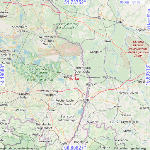
Horka GPS coordinates[2]
51° 18' 0" North, 14° 54' 0" East
| Map corner | latitude | longitude |
|---|---|---|
| Upper-left | 51.73752°, | 14.19688° |
| Center: | 51.3°, | 14.9° |
| Lower-right: | 50.85827°, | 15.60313° |
| Map W x H: | 97.8×97.8 km | = 60.8×60.8mi |
| max Lat: | 55.01917° ⇑36.8% North |
| Horka: | 51.3° |
| min Lat: | ⇓63.2% South 47.40724° |
| min Long | Horka | max Long |
| 5.92978° | 14.9° | 14.98853° |
| W 100%⇐ | ⇒0% E |
Elevation
Elevation of Horka is 164 m = 538 ft, and this is 85.1 m = 279 ft below average elevation for this country.
| Max E: |
1256 m = 4121 ft | 58.5% |
| Avg. | 249.1 m = 817 ft | |
| Horka | 164 m = 538 ft | |
Min E: |
-5 m = -16 ft | 41.5% |
See also: Germany elevation on elevation.city.
Geographical zone
Horka is located in North temperate zone (between Tropic of Cancer and the Arctic Circle). Distance of this North polar circle is 1697.1 km =1054.5 mi to North.| Distance of | km | miles | from Horka |
|---|---|---|---|
| North Pole | 4303 | 2673.8 | to North |
| Arctic Circle | 1697.1 | 1054.5 | to North |
| Tropic Cancer | 3098.1 | 1925.1 | to South |
| Equator | 5704 | 3544.3 | to South |


Nearby cities:
15 places around Horka: (largest is in red/bold)
• Guttau
24 km =14.9 mi,  259°
259°
• Görlitz
17.2 km =10.7 mi,  159°
159°
• Hähnichen
7.8 km =4.8 mi,  339°
339°
• Klitten
21.3 km =13.2 mi,  285°
285°
• Kodersdorf
6.4 km =4 mi,  184°
184°
• Königshain
13.2 km =8.2 mi,  190°
190°
• Markersdorf
18.6 km =11.6 mi, 183°
• Mücka
14 km =8.7 mi,  277°
277°
• Niesky
5.6 km =3.5 mi, 261°
• Quitzdorf
9.5 km =5.9 mi, 258°
• Reichenbach
18.9 km =11.7 mi,  201°
201°
• Rietschen
13.8 km =8.6 mi,  323°
323°
• Rothenburg
6.1 km =3.8 mi,  51°
51°
• Sohland am Rotstein
22 km =13.7 mi, 201°
• Weißenberg
20.4 km =12.7 mi,  235°
235°
Sources, notices
• [Note1] Compared only with cities in Germany existing in our database
• [Src1] Map data: © OpenStreetMap contributors (CC-BY-SA)
• [Src2] Other city data from geonames.org with taken over terms of usage.
• [Src3] Geographical zone / Annual Mean Temperature by Robert A. Rohde @ Wikipedia
