Kollnburg geodata
Kollnburg (Bavaria) is a seat of a fourth-order administrative division; located in Germany in Europe/Berlin (GMT+2) time zone. With population of 2,934 people, there are 4060 cities with bigger population in this country. Compared to other cities in Germany, 82.5% of cities are located further ↑North; 91.2% of cities are located further ←West and 96.6% of cities have lower elevation than Kollnburg. Note1
Administrative division(s):
- Level 1: Bavaria
- Level 2: Lower Bavaria
- Level 3: Landkreis Regen
- Level 4: Kollnburg


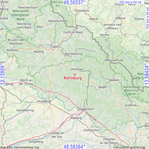
Kollnburg GPS coordinates[2]
49° 2' 47.904" North, 12° 51' 40.356" East
| Map corner | latitude | longitude |
|---|---|---|
| Upper-left | 49.50537°, | 12.15809° |
| Center: | 49.04664°, | 12.86121° |
| Lower-right: | 48.58364°, | 13.56434° |
| Map W x H: | 102.5×102.5 km | = 63.7×63.7mi |
| max Lat: | 55.01917° ⇑82.5% North |
| Kollnburg: | 49.04664° |
| min Lat: | ⇓17.5% South 47.40724° |
| min Long | Kollnburg | max Long |
| 5.92978° | 12.86121° | 14.98853° |
| W 91.2%⇐ | ⇒8.8% E |
Elevation
Elevation of Kollnburg is 649 m = 2129 ft, and this is 399.9 m = 1312 ft above average elevation for this country.
| Max E: |
1256 m = 4121 ft | 3.4% |
| Kollnburg | 649 m 2129 ft | |
| Avg. | 249.1 m = 817 ft | |
Min E: |
-5 m = -16 ft | 96.6% |
See also: Germany elevation on elevation.city.
Geographical zone
Kollnburg is located in North temperate zone (between Tropic of Cancer and the Arctic Circle). Distance of this North polar circle is 1947.7 km =1210.2 mi to North.| Distance of | km | miles | from Kollnburg |
|---|---|---|---|
| North Pole | 4553.6 | 2829.5 | to North |
| Arctic Circle | 1947.7 | 1210.2 | to North |
| Tropic Cancer | 2847.6 | 1769.4 | to South |
| Equator | 5453.5 | 3388.6 | to South |


Nearby cities:
15 places around Kollnburg: (largest is in red/bold)
• Achslach
9.9 km =6.2 mi,  147°
147°
• Böbrach
12.7 km =7.9 mi,  85°
85°
• Geiersthal
8.8 km =5.5 mi, 90°
• Gotteszell
11.8 km =7.3 mi,  139°
139°
• Haibach
10.9 km =6.8 mi,  256°
256°
• Konzell
11.3 km =7 mi,  284°
284°
• Neukirchen
11.1 km =6.9 mi,  224°
224°
• Patersdorf
9.5 km =5.9 mi,  110°
110°
• Perasdorf
11.6 km =7.2 mi,  202°
202°
• Prackenbach
6 km =3.7 mi,  334°
334°
• Rattenberg
9.3 km =5.8 mi,  298°
298°
• Ruhmannsfelden
11.4 km =7.1 mi,  128°
128°
• Sankt Englmar
5.5 km =3.4 mi,  207°
207°
• Teisnach
9.2 km =5.7 mi, 93°
• Viechtach
4.1 km =2.5 mi,  25°
25°
Sources, notices
• [Note1] Compared only with cities in Germany existing in our database
• [Src1] Map data: © OpenStreetMap contributors (CC-BY-SA)
• [Src2] Other city data from geonames.org with taken over terms of usage.
• [Src3] Geographical zone / Annual Mean Temperature by Robert A. Rohde @ Wikipedia
