Koblenz geodata
Koblenz (Rheinland-Pfalz) is a seat of a third-order administrative division; located in Germany in Europe/Berlin (GMT+2) time zone. With population of 107,319 people, there are 88 cities with bigger population in this country. Compared to other cities in Germany, 55.5% of cities are located further ↑North; 85.4% of cities are located further →East and 72.4% of cities have higher elevation than Koblenz. Note1
Administrative division(s):
- Level 1: Rheinland-Pfalz
- Level 3: Kreisfreie Stadt Koblenz
- Level 4: Koblenz


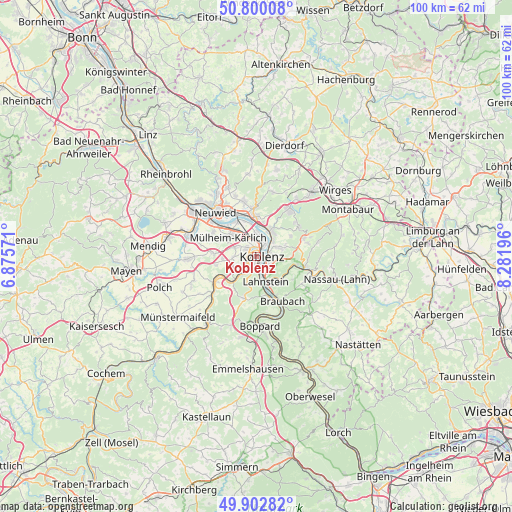
Koblenz GPS coordinates[2]
50° 21' 12.852" North, 7° 34' 43.788" East
| Map corner | latitude | longitude |
|---|---|---|
| Upper-left | 50.80008°, | 6.87571° |
| Center: | 50.35357°, | 7.57883° |
| Lower-right: | 49.90282°, | 8.28196° |
| Map W x H: | 99.8×99.8 km | = 62×62mi |
| max Lat: | 55.01917° ⇑55.5% North |
| Koblenz: | 50.35357° |
| min Lat: | ⇓44.5% South 47.40724° |
| min Long | Koblenz | max Long |
| 5.92978° | 7.57883° | 14.98853° |
| W 14.6%⇐ | ⇒85.4% E |
Elevation
Elevation of Koblenz is 75 m = 246 ft, and this is 174.1 m = 571 ft below average elevation for this country.
| Max E: |
1256 m = 4121 ft | 72.4% |
| Avg. | 249.1 m = 817 ft | |
| Koblenz | 75 m = 246 ft | |
Min E: |
-5 m = -16 ft | 27.6% |
See also: Koblenz elevation on elevation.city.
Geographical zone
Koblenz is located in North temperate zone (between Tropic of Cancer and the Arctic Circle). Distance of this North polar circle is 1802.4 km =1120 mi to North.| Distance of | km | miles | from Koblenz |
|---|---|---|---|
| North Pole | 4408.3 | 2739.2 | to North |
| Arctic Circle | 1802.4 | 1120 | to North |
| Tropic Cancer | 2992.9 | 1859.7 | to South |
| Equator | 5598.8 | 3478.9 | to South |


Nearby cities:
15 places around Koblenz: (largest is in red/bold)
• Bendorf
7.7 km =4.8 mi,  0°
0°
• Fachbach
7.7 km =4.8 mi,  106°
106°
• Kaltenengers
7.3 km =4.5 mi,  343°
343°
• Lahnstein
6.5 km =4 mi,  155°
155°
• Miellen
6.6 km =4.1 mi, 109°
• Mülheim-Kärlich
6.7 km =4.2 mi,  301°
301°
• Niederwerth
5.8 km =3.6 mi,  27°
27°
• Nievern
7.7 km =4.8 mi, 106°
• Sankt Sebastian
6.5 km =4 mi,  349°
349°
• Simmern
7.8 km =4.8 mi,  59°
59°
• Urbar
5.1 km =3.2 mi,  49°
49°
• Vallendar
5.7 km =3.5 mi, 34°
• Waldesch
8.1 km =5 mi,  194°
194°
• Weitersburg
7.2 km =4.5 mi,  12°
12°
• Winningen
6 km =3.7 mi,  227°
227°
In other languages:
- In Spanish: Coblenza
- In France: Coblence
- In Italian: Coblenza
- In Russian: Кобленц
- In Chinese: 科布倫茨
Sources, notices
• [Note1] Compared only with cities in Germany existing in our database
• [Src1] Map data: © OpenStreetMap contributors (CC-BY-SA)
• [Src2] Other city data from geonames.org with taken over terms of usage.
• [Src3] Geographical zone / Annual Mean Temperature by Robert A. Rohde @ Wikipedia
