Waldesch geodata
Waldesch (Rheinland-Pfalz) is a seat of a fourth-order administrative division; located in Germany in Europe/Berlin (GMT+2) time zone. In our database, there are 11009 cities with bigger population. Compared to other cities in Germany, 57.2% of cities are located further ↑North; 86.1% of cities are located further →East and 63.7% of cities have lower elevation than Waldesch. Note1
Administrative division(s):
- Level 1: Rheinland-Pfalz
- Level 3: Landkreis Mayen-Koblenz
- Level 4: Waldesch


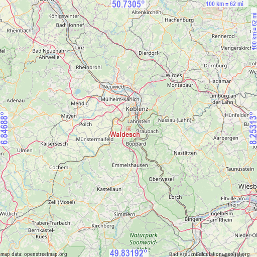
Waldesch GPS coordinates[2]
50° 16' 59.988" North, 7° 33' 0" East
| Map corner | latitude | longitude |
|---|---|---|
| Upper-left | 50.7305°, | 6.84688° |
| Center: | 50.28333°, | 7.55° |
| Lower-right: | 49.83192°, | 8.25313° |
| Map W x H: | 99.9×99.9 km | = 62.1×62.1mi |
| max Lat: | 55.01917° ⇑57.2% North |
| Waldesch: | 50.28333° |
| min Lat: | ⇓42.8% South 47.40724° |
| min Long | Waldesch | max Long |
| 5.92978° | 7.55° | 14.98853° |
| W 13.9%⇐ | ⇒86.1% E |
Elevation
Elevation of Waldesch is 313 m = 1027 ft, and this is 63.9 m = 210 ft above average elevation for this country.
| Max E: |
1256 m = 4121 ft | 36.3% |
| Waldesch | 313 m 1027 ft | |
| Avg. | 249.1 m = 817 ft | |
Min E: |
-5 m = -16 ft | 63.7% |
See also: Germany elevation on elevation.city.
Geographical zone
Waldesch is located in North temperate zone (between Tropic of Cancer and the Arctic Circle). Distance of this North polar circle is 1810.2 km =1124.8 mi to North.| Distance of | km | miles | from Waldesch |
|---|---|---|---|
| North Pole | 4416.1 | 2744 | to North |
| Arctic Circle | 1810.2 | 1124.8 | to North |
| Tropic Cancer | 2985.1 | 1854.9 | to South |
| Equator | 5591 | 3474.1 | to South |


Nearby cities:
15 places around Waldesch: (largest is in red/bold)
• Alken
8 km =5 mi,  242°
242°
• Boppard
6.5 km =4 mi,  154°
154°
• Braubach
6.8 km =4.2 mi,  99°
99°
• Brey
5.6 km =3.5 mi, 102°
• Dieblich
6.5 km =4 mi,  301°
301°
• Filsen
5.4 km =3.4 mi, 152°
• Kobern-Gondorf
7 km =4.3 mi,  287°
287°
• Lahnstein
5.1 km =3.2 mi,  68°
68°
• Lehmen
7.1 km =4.4 mi,  270°
270°
• Niederfell
5.9 km =3.7 mi, 270°
• Oberfell
7.9 km =4.9 mi,  251°
251°
• Osterspai
6.2 km =3.9 mi,  134°
134°
• Rhens
4.8 km =3 mi,  92°
92°
• Spay
7.5 km =4.7 mi,  111°
111°
• Winningen
4.4 km =2.7 mi,  327°
327°
Sources, notices
• [Note1] Compared only with cities in Germany existing in our database
• [Src1] Map data: © OpenStreetMap contributors (CC-BY-SA)
• [Src2] Other city data from geonames.org with taken over terms of usage.
• [Src3] Geographical zone / Annual Mean Temperature by Robert A. Rohde @ Wikipedia
