Kuhardt geodata
Kuhardt (Rheinland-Pfalz) is a seat of a fourth-order administrative division; located in Germany in Europe/Berlin (GMT+2) time zone. With population of 1,927 people, there are 5171 cities with bigger population in this country. Compared to other cities in Germany, 81.2% of cities are located further ↑North; 72.8% of cities are located further →East and 66.5% of cities have higher elevation than Kuhardt. Note1
Administrative division(s):
- Level 1: Rheinland-Pfalz
- Level 3: Landkreis Germersheim
- Level 4: Kuhardt


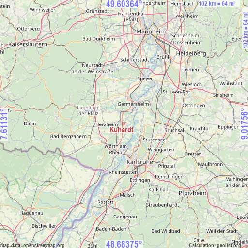
Kuhardt GPS coordinates[2]
49° 8' 44.988" North, 8° 18' 51.984" East
| Map corner | latitude | longitude |
|---|---|---|
| Upper-left | 49.60364°, | 7.61131° |
| Center: | 49.14583°, | 8.31444° |
| Lower-right: | 48.68375°, | 9.01756° |
| Map W x H: | 102.3×102.3 km | = 63.6×63.6mi |
| max Lat: | 55.01917° ⇑81.2% North |
| Kuhardt: | 49.14583° |
| min Lat: | ⇓18.8% South 47.40724° |
| min Long | Kuhardt | max Long |
| 5.92978° | 8.31444° | 14.98853° |
| W 27.2%⇐ | ⇒72.8% E |
Elevation
Elevation of Kuhardt is 111 m = 364 ft, and this is 138.1 m = 453 ft below average elevation for this country.
| Max E: |
1256 m = 4121 ft | 66.5% |
| Avg. | 249.1 m = 817 ft | |
| Kuhardt | 111 m = 364 ft | |
Min E: |
-5 m = -16 ft | 33.5% |
See also: Germany elevation on elevation.city.
Geographical zone
Kuhardt is located in North temperate zone (between Tropic of Cancer and the Arctic Circle). Distance of this North polar circle is 1936.7 km =1203.4 mi to North.| Distance of | km | miles | from Kuhardt |
|---|---|---|---|
| North Pole | 4542.6 | 2822.6 | to North |
| Arctic Circle | 1936.7 | 1203.4 | to North |
| Tropic Cancer | 2858.6 | 1776.3 | to South |
| Equator | 5464.5 | 3395.5 | to South |


Nearby cities:
15 places around Kuhardt: (largest is in red/bold)
• Bellheim
6.4 km =4 mi,  336°
336°
• Eggenstein-Leopoldshafen
8.7 km =5.4 mi,  135°
135°
• Germersheim
9.3 km =5.8 mi,  22°
22°
• Hatzenbühl
6.3 km =3.9 mi,  232°
232°
• Herxheim
7.3 km =4.5 mi,  270°
270°
• Herxheimweyher
4.4 km =2.7 mi,  279°
279°
• Hördt
2.4 km =1.5 mi, 21°
• Jockgrim
6.6 km =4.1 mi,  206°
206°
• Knittelsheim
6.9 km =4.3 mi,  318°
318°
• Leimersheim
3.3 km =2.1 mi, 136°
• Linkenheim-Hochstetten
7.3 km =4.5 mi,  102°
102°
• Neupotz
3.1 km =1.9 mi,  173°
173°
• Ottersheim
7.9 km =4.9 mi,  310°
310°
• Rheinzabern
4.1 km =2.5 mi,  220°
220°
• Rülzheim
1.8 km =1.1 mi,  297°
297°
Sources, notices
• [Note1] Compared only with cities in Germany existing in our database
• [Src1] Map data: © OpenStreetMap contributors (CC-BY-SA)
• [Src2] Other city data from geonames.org with taken over terms of usage.
• [Src3] Geographical zone / Annual Mean Temperature by Robert A. Rohde @ Wikipedia
