Kleve geodata
Kleve (North Rhine-Westphalia) is a seat of a third-order administrative division; located in Germany in Europe/Berlin (GMT+2) time zone. With population of 49,072 people, there are 234 cities with bigger population in this country. Compared to other cities in Germany, 69.8% of cities are located further ↓South; 99.9% of cities are located further →East and 87.3% of cities have higher elevation than Kleve. Note1
Administrative division(s):
- Level 1: North Rhine-Westphalia
- Level 2: Düsseldorf District
- Level 3: Kreis Kleve
- Level 4: Kleve


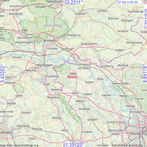
Kleve GPS coordinates[2]
51° 47' 17.736" North, 6° 8' 19.14" East
| Map corner | latitude | longitude |
|---|---|---|
| Upper-left | 52.2211°, | 5.43553° |
| Center: | 51.78826°, | 6.13865° |
| Lower-right: | 51.35123°, | 6.84178° |
| Map W x H: | 96.7×96.7 km | = 60.1×60.1mi |
| max Lat: | 55.01917° ⇑30.2% North |
| Kleve: | 51.78826° |
| min Lat: | ⇓69.8% South 47.40724° |
| min Long | Kleve | max Long |
| 5.92978° | 6.13865° | 14.98853° |
| W 0.1%⇐ | ⇒99.9% E |
Elevation
Elevation of Kleve is 29 m = 95 ft, and this is 220.1 m = 722 ft below average elevation for this country.
| Max E: |
1256 m = 4121 ft | 87.3% |
| Avg. | 249.1 m = 817 ft | |
| Kleve | 29 m = 95 ft | |
Min E: |
-5 m = -16 ft | 12.7% |
See also: Kleve elevation on elevation.city.
Geographical zone
Kleve is located in North temperate zone (between Tropic of Cancer and the Arctic Circle). Distance of this North polar circle is 1642.9 km =1020.9 mi to North.| Distance of | km | miles | from Kleve |
|---|---|---|---|
| North Pole | 4248.7 | 2640 | to North |
| Arctic Circle | 1642.9 | 1020.9 | to North |
| Tropic Cancer | 3152.4 | 1958.8 | to South |
| Equator | 5758.3 | 3578 | to South |


Nearby cities:
15 places around Kleve: (largest is in red/bold)
• Emmerich
9.4 km =5.8 mi,  52°
52°
• Geldern
32.5 km =20.2 mi,  156°
156°
• Goch
12.3 km =7.6 mi,  173°
173°
• Hamminkeln
31.7 km =19.7 mi,  101°
101°
• Isselburg
22.9 km =14.2 mi,  77°
77°
• Kalkar
11.8 km =7.3 mi,  117°
117°
• Kevelaer
24.1 km =15 mi, 162°
• Kranenburg
8.4 km =5.2 mi,  266°
266°
• Mehrhoog
26.3 km =16.3 mi, 102°
• Rees
18.1 km =11.2 mi, 99°
• Sonsbeck
26.1 km =16.2 mi,  140°
140°
• Uedem
16.5 km =10.3 mi,  145°
145°
• Weeze
18.4 km =11.4 mi, 167°
• Wemb
22.6 km =14 mi, 173°
• Xanten
26 km =16.2 mi, 123°
Sources, notices
• [Note1] Compared only with cities in Germany existing in our database
• [Src1] Map data: © OpenStreetMap contributors (CC-BY-SA)
• [Src2] Other city data from geonames.org with taken over terms of usage.
• [Src3] Geographical zone / Annual Mean Temperature by Robert A. Rohde @ Wikipedia
