Hamminkeln geodata
Hamminkeln (North Rhine-Westphalia) is a populated place; located in Germany in Europe/Berlin (GMT+2) time zone. With population of 27,433 people, there are 524 cities with bigger population in this country. Compared to other cities in Germany, 69.2% of cities are located further ↓South; 97.1% of cities are located further →East and 88.6% of cities have higher elevation than Hamminkeln. Note1
Administrative division(s):
- Level 1: North Rhine-Westphalia
- Level 2: Düsseldorf District
- Level 3: Kreis Wesel
- Level 4: Hamminkeln


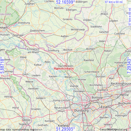
Hamminkeln GPS coordinates[2]
51° 43' 57.432" North, 6° 35' 25.116" East
| Map corner | latitude | longitude |
|---|---|---|
| Upper-left | 52.16599°, | 5.88718° |
| Center: | 51.73262°, | 6.59031° |
| Lower-right: | 51.29505°, | 7.29343° |
| Map W x H: | 96.8×96.8 km | = 60.1×60.1mi |
| max Lat: | 55.01917° ⇑30.8% North |
| Hamminkeln: | 51.73262° |
| min Lat: | ⇓69.2% South 47.40724° |
| min Long | Hamminkeln | max Long |
| 5.92978° | 6.59031° | 14.98853° |
| W 2.9%⇐ | ⇒97.1% E |
Elevation
Elevation of Hamminkeln is 25 m = 82 ft, and this is 224.1 m = 735 ft below average elevation for this country.
| Max E: |
1256 m = 4121 ft | 88.6% |
| Avg. | 249.1 m = 817 ft | |
| Hamminkeln | 25 m = 82 ft | |
Min E: |
-5 m = -16 ft | 11.4% |
See also: Germany elevation on elevation.city.
Geographical zone
Hamminkeln is located in North temperate zone (between Tropic of Cancer and the Arctic Circle). Distance of this North polar circle is 1649 km =1024.6 mi to North.| Distance of | km | miles | from Hamminkeln |
|---|---|---|---|
| North Pole | 4254.9 | 2643.9 | to North |
| Arctic Circle | 1649 | 1024.6 | to North |
| Tropic Cancer | 3146.2 | 1955 | to South |
| Equator | 5752.1 | 3574.2 | to South |


Nearby cities:
15 places around Hamminkeln: (largest is in red/bold)
• Alpen
17.4 km =10.8 mi,  197°
197°
• Bocholt
11.9 km =7.4 mi,  8°
8°
• Hünxe
13.2 km =8.2 mi,  146°
146°
• Isselburg
14.1 km =8.8 mi,  321°
321°
• Kalkar
20.6 km =12.8 mi,  271°
271°
• Mehrhoog
5.5 km =3.4 mi,  276°
276°
• Raesfeld
18.3 km =11.4 mi,  78°
78°
• Rees
13.7 km =8.5 mi, 284°
• Rhede
13.5 km =8.4 mi,  32°
32°
• Rheinberg
20.7 km =12.9 mi,  179°
179°
• Schermbeck
19.8 km =12.3 mi,  106°
106°
• Sonsbeck
20.1 km =12.5 mi,  226°
226°
• Voerde
16.5 km =10.3 mi,  156°
156°
• Wesel
7.6 km =4.7 mi, 164°
• Xanten
12.5 km =7.8 mi, 229°
Sources, notices
• [Note1] Compared only with cities in Germany existing in our database
• [Src1] Map data: © OpenStreetMap contributors (CC-BY-SA)
• [Src2] Other city data from geonames.org with taken over terms of usage.
• [Src3] Geographical zone / Annual Mean Temperature by Robert A. Rohde @ Wikipedia
