Klein-Winternheim geodata
Klein-Winternheim (Rheinland-Pfalz) is a seat of a fourth-order administrative division; located in Germany in Europe/Berlin (GMT+2) time zone. With population of 3,485 people, there are 3624 cities with bigger population in this country. Compared to other cities in Germany, 65.3% of cities are located further ↑North; 73.9% of cities are located further →East and 59.6% of cities have higher elevation than Klein-Winternheim. Note1
Administrative division(s):
- Level 1: Rheinland-Pfalz
- Level 3: Landkreis Mainz-Bingen
- Level 4: Klein-Winternheim


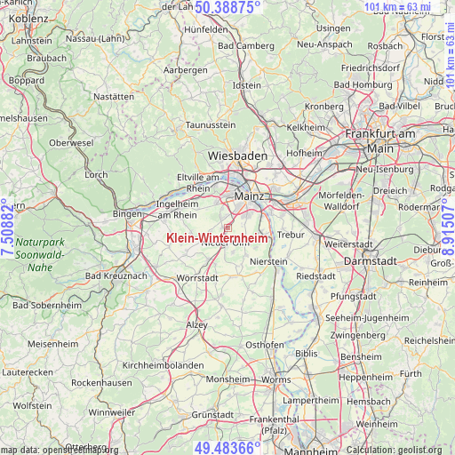
Klein-Winternheim GPS coordinates[2]
49° 56' 17.988" North, 8° 12' 42.984" East
| Map corner | latitude | longitude |
|---|---|---|
| Upper-left | 50.38875°, | 7.50882° |
| Center: | 49.93833°, | 8.21194° |
| Lower-right: | 49.48366°, | 8.91507° |
| Map W x H: | 100.6×100.6 km | = 62.5×62.5mi |
| max Lat: | 55.01917° ⇑65.3% North |
| Klein-Winternheim: | 49.93833° |
| min Lat: | ⇓34.7% South 47.40724° |
| min Long | Klein-Winternhe | max Long |
| 5.92978° | 8.21194° | 14.98853° |
| W 26.1%⇐ | ⇒73.9% E |
Elevation
Elevation of Klein-Winternheim is 156 m = 512 ft, and this is 93.1 m = 305 ft below average elevation for this country.
| Max E: |
1256 m = 4121 ft | 59.6% |
| Avg. | 249.1 m = 817 ft | |
| Klein-Winternheim | 156 m = 512 ft | |
Min E: |
-5 m = -16 ft | 40.4% |
See also: Germany elevation on elevation.city.
Geographical zone
Klein-Winternheim is located in North temperate zone (between Tropic of Cancer and the Arctic Circle). Distance of this North polar circle is 1848.6 km =1148.7 mi to North.| Distance of | km | miles | from Klein-Winternheim |
|---|---|---|---|
| North Pole | 4454.4 | 2767.8 | to North |
| Arctic Circle | 1848.6 | 1148.7 | to North |
| Tropic Cancer | 2946.7 | 1831 | to South |
| Equator | 5552.6 | 3450.2 | to South |


Nearby cities:
15 places around Klein-Winternheim: (largest is in red/bold)
• Bodenheim
7.7 km =4.8 mi,  92°
92°
• Essenheim
4.1 km =2.5 mi,  257°
257°
• Gau-Bischofsheim
5 km =3.1 mi,  119°
119°
• Harxheim
5.2 km =3.2 mi,  134°
134°
• Lörzweiler
7.4 km =4.6 mi, 126°
• Mainz
7 km =4.3 mi,  43°
43°
• Mommenheim
7.5 km =4.7 mi,  149°
149°
• Nieder-Olm
3 km =1.9 mi,  189°
189°
• Ober-Olm
1.7 km =1.1 mi,  265°
265°
• Schwabenheim
8.4 km =5.2 mi, 262°
• Stadecken-Elsheim
6.8 km =4.2 mi,  244°
244°
• Sörgenloch
6.2 km =3.9 mi, 187°
• Udenheim
8.7 km =5.4 mi,  199°
199°
• Wackernheim
7.9 km =4.9 mi,  300°
300°
• Zornheim
5.5 km =3.4 mi,  170°
170°
Sources, notices
• [Note1] Compared only with cities in Germany existing in our database
• [Src1] Map data: © OpenStreetMap contributors (CC-BY-SA)
• [Src2] Other city data from geonames.org with taken over terms of usage.
• [Src3] Geographical zone / Annual Mean Temperature by Robert A. Rohde @ Wikipedia
