Zornheim geodata
Zornheim (Rheinland-Pfalz) is a seat of a fourth-order administrative division; located in Germany in Europe/Berlin (GMT+2) time zone. With population of 3,559 people, there are 3571 cities with bigger population in this country. Compared to other cities in Germany, 66.7% of cities are located further ↑North; 73.8% of cities are located further →East and 51.2% of cities have higher elevation than Zornheim. Note1
Administrative division(s):
- Level 1: Rheinland-Pfalz
- Level 3: Landkreis Mainz-Bingen
- Level 4: Zornheim


Zornheim GPS coordinates[2]
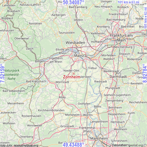
49° 53' 24" North, 8° 13' 28.992" East
| Map corner | latitude | longitude |
|---|---|---|
| Upper-left | 50.34087°, | 7.52159° |
| Center: | 49.89°, | 8.22472° |
| Lower-right: | 49.43488°, | 8.92784° |
| Map W x H: | 100.7×100.7 km | = 62.6×62.6mi |
| max Lat: | 55.01917° ⇑66.7% North |
| Zornheim: | 49.89° |
| min Lat: | ⇓33.3% South 47.40724° |
| min Long | Zornheim | max Long |
| 5.92978° | 8.22472° | 14.98853° |
| W 26.2%⇐ | ⇒73.8% E |
Elevation
Elevation of Zornheim is 217 m = 712 ft, and this is 32.1 m = 105 ft below average elevation for this country.
| Max E: |
1256 m = 4121 ft | 51.2% |
| Avg. | 249.1 m = 817 ft | |
| Zornheim | 217 m = 712 ft | |
Min E: |
-5 m = -16 ft | 48.8% |
See also: Germany elevation on elevation.city.
Geographical zone
Zornheim is located in North temperate zone (between Tropic of Cancer and the Arctic Circle). Distance of this North polar circle is 1853.9 km =1152 mi to North.| Distance of | km | miles | from Zornheim |
|---|---|---|---|
| North Pole | 4459.8 | 2771.2 | to North |
| Arctic Circle | 1853.9 | 1152 | to North |
| Tropic Cancer | 2941.3 | 1827.6 | to South |
| Equator | 5547.2 | 3446.9 | to South |


Nearby cities:
15 places around Zornheim: (largest is in red/bold)
• Friesenheim
6.4 km =4 mi,  158°
158°
• Gau-Bischofsheim
4.5 km =2.8 mi,  50°
50°
• Hahnheim
3.4 km =2.1 mi, 164°
• Harxheim
3.3 km =2.1 mi,  58°
58°
• Klein-Winternheim
5.5 km =3.4 mi,  350°
350°
• Köngernheim
5.2 km =3.2 mi, 162°
• Lörzweiler
5.1 km =3.2 mi,  79°
79°
• Mommenheim
3.1 km =1.9 mi,  110°
110°
• Nieder-Olm
2.8 km =1.7 mi,  330°
330°
• Ober-Olm
5.8 km =3.6 mi, 333°
• Schornsheim
6.1 km =3.8 mi,  215°
215°
• Selzen
3.9 km =2.4 mi,  146°
146°
• Sörgenloch
1.9 km =1.2 mi,  245°
245°
• Udenheim
4.7 km =2.9 mi,  233°
233°
• Undenheim
5.8 km =3.6 mi,  184°
184°
Sources, notices
• [Note1] Compared only with cities in Germany existing in our database
• [Src1] Map data: © OpenStreetMap contributors (CC-BY-SA)
• [Src2] Other city data from geonames.org with taken over terms of usage.
• [Src3] Geographical zone / Annual Mean Temperature by Robert A. Rohde @ Wikipedia
