Essenheim geodata
Essenheim (Rheinland-Pfalz) is a seat of a fourth-order administrative division; located in Germany in Europe/Berlin (GMT+2) time zone. With population of 3,161 people, there are 3861 cities with bigger population in this country. Compared to other cities in Germany, 65.6% of cities are located further ↑North; 74.6% of cities are located further →East and 50.9% of cities have higher elevation than Essenheim. Note1
Administrative division(s):
- Level 1: Rheinland-Pfalz
- Level 3: Landkreis Mainz-Bingen
- Level 4: Essenheim


Essenheim GPS coordinates[2]
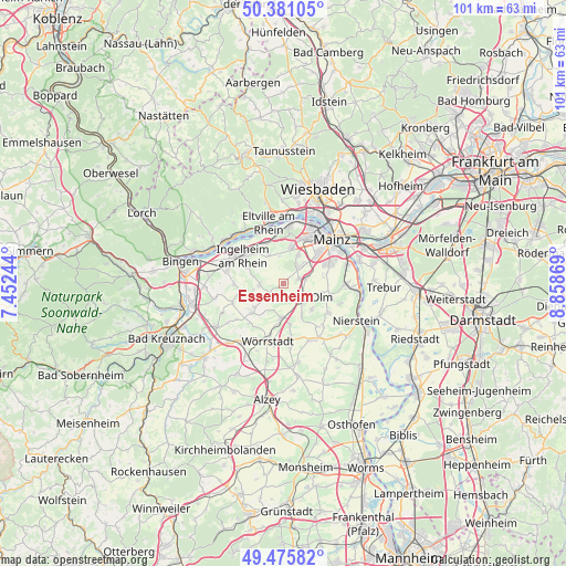
49° 55' 50.016" North, 8° 9' 20.016" East
| Map corner | latitude | longitude |
|---|---|---|
| Upper-left | 50.38105°, | 7.45244° |
| Center: | 49.93056°, | 8.15556° |
| Lower-right: | 49.47582°, | 8.85869° |
| Map W x H: | 100.7×100.7 km | = 62.6×62.6mi |
| max Lat: | 55.01917° ⇑65.6% North |
| Essenheim: | 49.93056° |
| min Lat: | ⇓34.4% South 47.40724° |
| min Long | Essenheim | max Long |
| 5.92978° | 8.15556° | 14.98853° |
| W 25.4%⇐ | ⇒74.6% E |
Elevation
Elevation of Essenheim is 219 m = 719 ft, and this is 30.1 m = 99 ft below average elevation for this country.
| Max E: |
1256 m = 4121 ft | 50.9% |
| Avg. | 249.1 m = 817 ft | |
| Essenheim | 219 m = 719 ft | |
Min E: |
-5 m = -16 ft | 49.1% |
See also: Germany elevation on elevation.city.
Geographical zone
Essenheim is located in North temperate zone (between Tropic of Cancer and the Arctic Circle). Distance of this North polar circle is 1849.4 km =1149.2 mi to North.| Distance of | km | miles | from Essenheim |
|---|---|---|---|
| North Pole | 4455.3 | 2768.4 | to North |
| Arctic Circle | 1849.4 | 1149.2 | to North |
| Tropic Cancer | 2945.8 | 1830.4 | to South |
| Equator | 5551.8 | 3449.7 | to South |


Nearby cities:
15 places around Essenheim: (largest is in red/bold)
• Bubenheim
5.5 km =3.4 mi,  259°
259°
• Engelstadt
7.1 km =4.4 mi,  245°
245°
• Jugenheim
6.5 km =4 mi,  231°
231°
• Klein-Winternheim
4.1 km =2.5 mi,  77°
77°
• Nieder-Ingelheim
7.9 km =4.9 mi,  311°
311°
• Nieder-Olm
4.1 km =2.5 mi,  120°
120°
• Ober-Olm
2.5 km =1.6 mi,  72°
72°
• Ober-Saulheim
7.6 km =4.7 mi,  191°
191°
• Partenheim
7.4 km =4.6 mi, 225°
• Schwabenheim
4.3 km =2.7 mi,  267°
267°
• Stadecken-Elsheim
3 km =1.9 mi, 226°
• Sörgenloch
6.2 km =3.9 mi,  148°
148°
• Udenheim
7.4 km =4.6 mi,  171°
171°
• Wackernheim
5.6 km =3.5 mi,  330°
330°
• Zornheim
6.7 km =4.2 mi,  132°
132°
Sources, notices
• [Note1] Compared only with cities in Germany existing in our database
• [Src1] Map data: © OpenStreetMap contributors (CC-BY-SA)
• [Src2] Other city data from geonames.org with taken over terms of usage.
• [Src3] Geographical zone / Annual Mean Temperature by Robert A. Rohde @ Wikipedia
