Stadecken-Elsheim geodata
Stadecken-Elsheim (Rheinland-Pfalz) is a seat of a fourth-order administrative division; located in Germany in Europe/Berlin (GMT+2) time zone. With population of 4,438 people, there are 3071 cities with bigger population in this country. Compared to other cities in Germany, 66.1% of cities are located further ↑North; 75% of cities are located further →East and 66.7% of cities have higher elevation than Stadecken-Elsheim. Note1
Administrative division(s):
- Level 1: Rheinland-Pfalz
- Level 3: Landkreis Mainz-Bingen
- Level 4: Stadecken-Elsheim


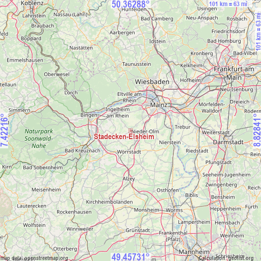
Stadecken-Elsheim GPS coordinates[2]
49° 54' 43.992" North, 8° 7' 31.008" East
| Map corner | latitude | longitude |
|---|---|---|
| Upper-left | 50.36288°, | 7.42216° |
| Center: | 49.91222°, | 8.12528° |
| Lower-right: | 49.45731°, | 8.82841° |
| Map W x H: | 100.7×100.7 km | = 62.6×62.6mi |
| max Lat: | 55.01917° ⇑66.1% North |
| Stadecken-Elsheim: | 49.91222° |
| min Lat: | ⇓33.9% South 47.40724° |
| min Long | Stadecken-Elshe | max Long |
| 5.92978° | 8.12528° | 14.98853° |
| W 25%⇐ | ⇒75% E |
Elevation
Elevation of Stadecken-Elsheim is 110 m = 361 ft, and this is 139.1 m = 456 ft below average elevation for this country.
| Max E: |
1256 m = 4121 ft | 66.7% |
| Avg. | 249.1 m = 817 ft | |
| Stadecken-Elsheim | 110 m = 361 ft | |
Min E: |
-5 m = -16 ft | 33.3% |
See also: Germany elevation on elevation.city.
Geographical zone
Stadecken-Elsheim is located in North temperate zone (between Tropic of Cancer and the Arctic Circle). Distance of this North polar circle is 1851.5 km =1150.5 mi to North.| Distance of | km | miles | from Stadecken-Elsheim |
|---|---|---|---|
| North Pole | 4457.3 | 2769.6 | to North |
| Arctic Circle | 1851.5 | 1150.5 | to North |
| Tropic Cancer | 2943.8 | 1829.2 | to South |
| Equator | 5549.7 | 3448.4 | to South |


Nearby cities:
15 places around Stadecken-Elsheim: (largest is in red/bold)
• Appenheim
6.9 km =4.3 mi,  286°
286°
• Bubenheim
3.4 km =2.1 mi, 287°
• Engelstadt
4.4 km =2.7 mi,  258°
258°
• Essenheim
3 km =1.9 mi,  46°
46°
• Jugenheim
3.6 km =2.2 mi,  234°
234°
• Klein-Winternheim
6.8 km =4.2 mi,  64°
64°
• Nieder-Hilbersheim
6 km =3.7 mi,  271°
271°
• Nieder-Olm
5.7 km =3.5 mi,  90°
90°
• Ober-Olm
5.3 km =3.3 mi, 58°
• Ober-Saulheim
5.4 km =3.4 mi,  172°
172°
• Partenheim
4.4 km =2.7 mi,  224°
224°
• Schwabenheim
2.8 km =1.7 mi,  310°
310°
• Sörgenloch
6.3 km =3.9 mi,  120°
120°
• Udenheim
6.2 km =3.9 mi,  147°
147°
• Vendersheim
6.5 km =4 mi, 218°
Sources, notices
• [Note1] Compared only with cities in Germany existing in our database
• [Src1] Map data: © OpenStreetMap contributors (CC-BY-SA)
• [Src2] Other city data from geonames.org with taken over terms of usage.
• [Src3] Geographical zone / Annual Mean Temperature by Robert A. Rohde @ Wikipedia
