Kleinwenden geodata
Kleinwenden (Thuringia) is a populated place; located in Germany in Europe/Berlin (GMT+2) time zone. With population of 1,043 people, there are 7036 cities with bigger population in this country. Compared to other cities in Germany, 65% of cities are located further ↓South; 61.8% of cities are located further ←West and 64.7% of cities have lower elevation than Kleinwenden. Note1


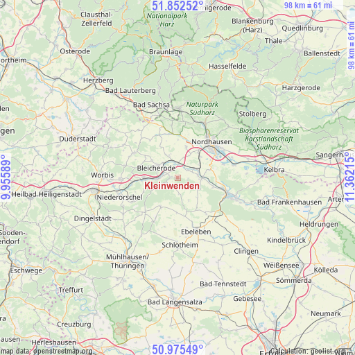
Kleinwenden GPS coordinates[2]
51° 24' 57.996" North, 10° 39' 32.472" East
| Map corner | latitude | longitude |
|---|---|---|
| Upper-left | 51.85252°, | 9.95589° |
| Center: | 51.41611°, | 10.65902° |
| Lower-right: | 50.97549°, | 11.36215° |
| Map W x H: | 97.5×97.5 km | = 60.6×60.6mi |
| max Lat: | 55.01917° ⇑35% North |
| Kleinwenden: | 51.41611° |
| min Lat: | ⇓65% South 47.40724° |
| min Long | Kleinwenden | max Long |
| 5.92978° | 10.65902° | 14.98853° |
| W 61.8%⇐ | ⇒38.2% E |
Elevation
Elevation of Kleinwenden is 319 m = 1047 ft, and this is 69.9 m = 229 ft above average elevation for this country.
| Max E: |
1256 m = 4121 ft | 35.3% |
| Kleinwenden | 319 m 1047 ft | |
| Avg. | 249.1 m = 817 ft | |
Min E: |
-5 m = -16 ft | 64.7% |
See also: Germany elevation on elevation.city.
Geographical zone
Kleinwenden is located in North temperate zone (between Tropic of Cancer and the Arctic Circle). Distance of this North polar circle is 1684.2 km =1046.5 mi to North.| Distance of | km | miles | from Kleinwenden |
|---|---|---|---|
| North Pole | 4290.1 | 2665.7 | to North |
| Arctic Circle | 1684.2 | 1046.5 | to North |
| Tropic Cancer | 3111 | 1933.1 | to South |
| Equator | 5716.9 | 3552.3 | to South |


Nearby cities:
15 places around Kleinwenden: (largest is in red/bold)
• Bleicherode
6.6 km =4.1 mi,  293°
293°
• Etzelsrode
9.8 km =6.1 mi,  342°
342°
• Friedrichsthal
9.1 km =5.7 mi,  324°
324°
• Kehmstedt
7.2 km =4.5 mi,  332°
332°
• Kleinbodungen
10.4 km =6.5 mi,  302°
302°
• Kleinfurra
7.3 km =4.5 mi,  90°
90°
• Kraja
10.6 km =6.6 mi, 290°
• Lipprechterode
8.7 km =5.4 mi, 302°
• Niedergebra
4.2 km =2.6 mi,  280°
280°
• Nohra
3.4 km =2.1 mi,  56°
56°
• Obergebra
5.5 km =3.4 mi,  267°
267°
• Rehungen
10.2 km =6.3 mi,  248°
248°
• Sollstedt
8.7 km =5.4 mi, 270°
• Wipperdorf
4.5 km =2.8 mi,  346°
346°
• Wolkramshausen
5.5 km =3.4 mi,  83°
83°
Sources, notices
• [Note1] Compared only with cities in Germany existing in our database
• [Src1] Map data: © OpenStreetMap contributors (CC-BY-SA)
• [Src2] Other city data from geonames.org with taken over terms of usage.
• [Src3] Geographical zone / Annual Mean Temperature by Robert A. Rohde @ Wikipedia
