Kleinfurra geodata
Kleinfurra (Thuringia) is a seat of a fourth-order administrative division; located in Germany in Europe/Berlin (GMT+2) time zone. With population of 1,243 people, there are 6465 cities with bigger population in this country. Compared to other cities in Germany, 65% of cities are located further ↓South; 63.5% of cities are located further ←West and 53.4% of cities have higher elevation than Kleinfurra. Note1


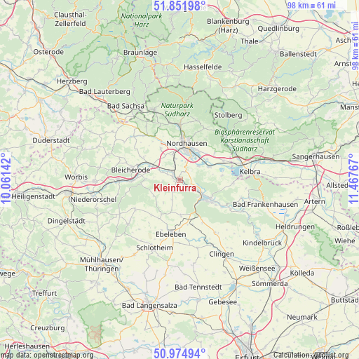
Kleinfurra GPS coordinates[2]
51° 24' 56.016" North, 10° 45' 52.344" East
| Map corner | latitude | longitude |
|---|---|---|
| Upper-left | 51.85198°, | 10.06142° |
| Center: | 51.41556°, | 10.76454° |
| Lower-right: | 50.97494°, | 11.46767° |
| Map W x H: | 97.5×97.5 km | = 60.6×60.6mi |
| max Lat: | 55.01917° ⇑35% North |
| Kleinfurra: | 51.41556° |
| min Lat: | ⇓65% South 47.40724° |
| min Long | Kleinfurra | max Long |
| 5.92978° | 10.76454° | 14.98853° |
| W 63.5%⇐ | ⇒36.5% E |
Elevation
Elevation of Kleinfurra is 201 m = 659 ft, and this is 48.1 m = 158 ft below average elevation for this country.
| Max E: |
1256 m = 4121 ft | 53.4% |
| Avg. | 249.1 m = 817 ft | |
| Kleinfurra | 201 m = 659 ft | |
Min E: |
-5 m = -16 ft | 46.6% |
See also: Germany elevation on elevation.city.
Geographical zone
Kleinfurra is located in North temperate zone (between Tropic of Cancer and the Arctic Circle). Distance of this North polar circle is 1684.3 km =1046.6 mi to North.| Distance of | km | miles | from Kleinfurra |
|---|---|---|---|
| North Pole | 4290.2 | 2665.8 | to North |
| Arctic Circle | 1684.3 | 1046.6 | to North |
| Tropic Cancer | 3111 | 1933.1 | to South |
| Equator | 5716.9 | 3552.3 | to South |


Nearby cities:
15 places around Kleinfurra: (largest is in red/bold)
• Auleben
11.5 km =7.1 mi,  83°
83°
• Heringen
8.5 km =5.3 mi,  65°
65°
• Kehmstedt
12.4 km =7.7 mi,  300°
300°
• Kleinwenden
7.3 km =4.5 mi,  270°
270°
• Niedergebra
11.4 km =7.1 mi, 274°
• Nohra
4.9 km =3 mi,  293°
293°
• Nordhausen
9.8 km =6.1 mi,  12°
12°
• Obergebra
12.8 km =8 mi, 269°
• Schernberg
9.8 km =6.1 mi,  178°
178°
• Sondershausen
8.9 km =5.5 mi,  124°
124°
• Urbach
11.9 km =7.4 mi,  52°
52°
• Uthleben
6.3 km =3.9 mi, 53°
• Windehausen
9.4 km =5.8 mi, 53°
• Wipperdorf
9.5 km =5.9 mi, 298°
• Wolkramshausen
2 km =1.2 mi, 290°
Sources, notices
• [Note1] Compared only with cities in Germany existing in our database
• [Src1] Map data: © OpenStreetMap contributors (CC-BY-SA)
• [Src2] Other city data from geonames.org with taken over terms of usage.
• [Src3] Geographical zone / Annual Mean Temperature by Robert A. Rohde @ Wikipedia
