Friedrichsthal geodata
Friedrichsthal (Thuringia) is a seat of a fourth-order administrative division; located in Germany in Europe/Berlin (GMT+1) time zone. With population of 286 people, there are 10108 cities with bigger population in this country. Compared to other cities in Germany, 66.1% of cities are located further ↓South; 60.4% of cities are located further ←West and 54.3% of cities have lower elevation than Friedrichsthal. Note1
Administrative division(s):
- Level 1: Thuringia
- Level 3: Landkreis Nordhausen
- Level 4: Stadt Bleicherode


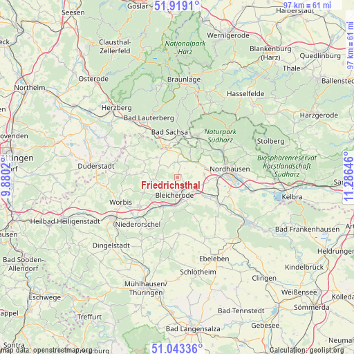
Friedrichsthal GPS coordinates[2]
51° 28' 59.988" North, 10° 34' 59.988" East
| Map corner | latitude | longitude |
|---|---|---|
| Upper-left | 51.9191°, | 9.8802° |
| Center: | 51.48333°, | 10.58333° |
| Lower-right: | 51.04336°, | 11.28646° |
| Map W x H: | 97.4×97.4 km | = 60.5×60.5mi |
| max Lat: | 55.01917° ⇑33.9% North |
| Friedrichsthal: | 51.48333° |
| min Lat: | ⇓66.1% South 47.40724° |
| min Long | Friedrichsthal | max Long |
| 5.92978° | 10.58333° | 14.98853° |
| W 60.4%⇐ | ⇒39.6% E |
Elevation
Elevation of Friedrichsthal is 254 m = 833 ft, and this is 4.9 m = 16 ft above average elevation for this country.
| Max E: |
1256 m = 4121 ft | 45.7% |
| Friedrichsthal | 254 m 833 ft | |
| Avg. | 249.1 m = 817 ft | |
Min E: |
-5 m = -16 ft | 54.3% |
See also: Germany elevation on elevation.city.
Geographical zone
Friedrichsthal is located in North temperate zone (between Tropic of Cancer and the Arctic Circle). Distance of this North polar circle is 1676.8 km =1041.9 mi to North.| Distance of | km | miles | from Friedrichsthal |
|---|---|---|---|
| North Pole | 4282.7 | 2661.1 | to North |
| Arctic Circle | 1676.8 | 1041.9 | to North |
| Tropic Cancer | 3118.5 | 1937.7 | to South |
| Equator | 5724.4 | 3557 | to South |


Nearby cities:
15 places around Friedrichsthal: (largest is in red/bold)
• Bleicherode
4.9 km =3 mi,  189°
189°
• Etzelsrode
3 km =1.9 mi,  51°
51°
• Großbodungen
7.1 km =4.4 mi,  263°
263°
• Kehmstedt
2.2 km =1.4 mi,  120°
120°
• Kleinbodungen
3.9 km =2.4 mi,  241°
241°
• Kleinwenden
9.1 km =5.7 mi,  144°
144°
• Kraja
5.9 km =3.7 mi,  231°
231°
• Lipprechterode
3.5 km =2.2 mi,  215°
215°
• Neustadt
8.2 km =5.1 mi, 257°
• Niedergebra
6.8 km =4.2 mi,  170°
170°
• Nohra
9.8 km =6.1 mi, 124°
• Obergebra
7.8 km =4.8 mi,  181°
181°
• Sollstedt
8.2 km =5.1 mi,  205°
205°
• Steinrode
6.6 km =4.1 mi,  288°
288°
• Wipperdorf
5.2 km =3.2 mi,  126°
126°
Sources, notices
• [Note1] Compared only with cities in Germany existing in our database
• [Src1] Map data: © OpenStreetMap contributors (CC-BY-SA)
• [Src2] Other city data from geonames.org with taken over terms of usage.
• [Src3] Geographical zone / Annual Mean Temperature by Robert A. Rohde @ Wikipedia
