Kirrweiler geodata
Kirrweiler (Rheinland-Pfalz) is a populated place; located in Germany in Europe/Berlin (GMT+2) time zone. With population of 2,034 people, there are 5016 cities with bigger population in this country. Compared to other cities in Germany, 78.6% of cities are located further ↑North; 74.6% of cities are located further →East and 61.9% of cities have higher elevation than Kirrweiler. Note1
Administrative division(s):
- Level 1: Rheinland-Pfalz
- Level 3: Landkreis Südliche Weinstraße
- Level 4: Kirrweiler (Pfalz)


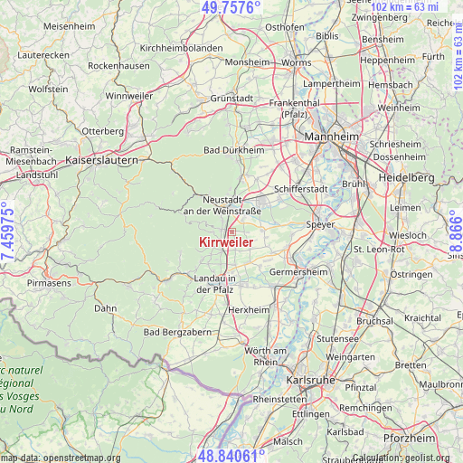
Kirrweiler GPS coordinates[2]
49° 18' 4.464" North, 8° 9' 46.368" East
| Map corner | latitude | longitude |
|---|---|---|
| Upper-left | 49.7576°, | 7.45975° |
| Center: | 49.30124°, | 8.16288° |
| Lower-right: | 48.84061°, | 8.866° |
| Map W x H: | 102×102 km | = 63.4×63.4mi |
| max Lat: | 55.01917° ⇑78.6% North |
| Kirrweiler: | 49.30124° |
| min Lat: | ⇓21.4% South 47.40724° |
| min Long | Kirrweiler | max Long |
| 5.92978° | 8.16288° | 14.98853° |
| W 25.4%⇐ | ⇒74.6% E |
Elevation
Elevation of Kirrweiler is 139 m = 456 ft, and this is 110.1 m = 361 ft below average elevation for this country.
| Max E: |
1256 m = 4121 ft | 61.9% |
| Avg. | 249.1 m = 817 ft | |
| Kirrweiler | 139 m = 456 ft | |
Min E: |
-5 m = -16 ft | 38.1% |
See also: Germany elevation on elevation.city.
Geographical zone
Kirrweiler is located in North temperate zone (between Tropic of Cancer and the Arctic Circle). Distance of this North polar circle is 1919.4 km =1192.7 mi to North.| Distance of | km | miles | from Kirrweiler |
|---|---|---|---|
| North Pole | 4525.3 | 2811.9 | to North |
| Arctic Circle | 1919.4 | 1192.7 | to North |
| Tropic Cancer | 2875.9 | 1787 | to South |
| Equator | 5481.8 | 3406.2 | to South |


Nearby cities:
15 places around Kirrweiler: (largest is in red/bold)
• Altdorf
4.2 km =2.6 mi,  111°
111°
• Böbingen
5.7 km =3.5 mi, 109°
• Edenkoben
3.2 km =2 mi,  233°
233°
• Edesheim
4.7 km =2.9 mi,  205°
205°
• Freimersheim
5.6 km =3.5 mi,  128°
128°
• Großfischlingen
3.7 km =2.3 mi,  164°
164°
• Hainfeld
6.6 km =4.1 mi,  222°
222°
• Hochstadt
6.8 km =4.2 mi,  150°
150°
• Kleinfischlingen
4.6 km =2.9 mi, 157°
• Lachen-Speyerdorf
4.2 km =2.6 mi,  39°
39°
• Maikammer
2.3 km =1.4 mi,  281°
281°
• Neustadt
5.7 km =3.5 mi,  342°
342°
• Rhodt unter Rietburg
5.3 km =3.3 mi, 228°
• Sankt Martin
4.2 km =2.6 mi,  268°
268°
• Venningen
2.3 km =1.4 mi, 160°
Sources, notices
• [Note1] Compared only with cities in Germany existing in our database
• [Src1] Map data: © OpenStreetMap contributors (CC-BY-SA)
• [Src2] Other city data from geonames.org with taken over terms of usage.
• [Src3] Geographical zone / Annual Mean Temperature by Robert A. Rohde @ Wikipedia
