Sankt Martin geodata
Sankt Martin (Rheinland-Pfalz) is a seat of a fourth-order administrative division; located in Germany in Europe/Berlin (GMT+2) time zone. With population of 1,872 people, there are 5244 cities with bigger population in this country. Compared to other cities in Germany, 78.6% of cities are located further ↑North; 75.4% of cities are located further →East and 50.3% of cities have lower elevation than Sankt Martin. Note1
Administrative division(s):
- Level 1: Rheinland-Pfalz
- Level 3: Landkreis Südliche Weinstraße
- Level 4: Sankt Martin


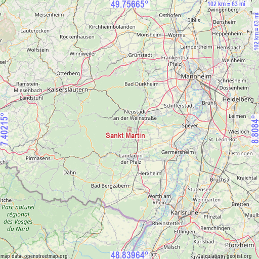
Sankt Martin GPS coordinates[2]
49° 18' 1.008" North, 8° 6' 19.008" East
| Map corner | latitude | longitude |
|---|---|---|
| Upper-left | 49.75665°, | 7.40215° |
| Center: | 49.30028°, | 8.10528° |
| Lower-right: | 48.83964°, | 8.8084° |
| Map W x H: | 102×102 km | = 63.4×63.4mi |
| max Lat: | 55.01917° ⇑78.6% North |
| Sankt Martin: | 49.30028° |
| min Lat: | ⇓21.4% South 47.40724° |
| min Long | Sankt Martin | max Long |
| 5.92978° | 8.10528° | 14.98853° |
| W 24.6%⇐ | ⇒75.4% E |
Elevation
Elevation of Sankt Martin is 228 m = 748 ft, and this is 21.1 m = 69 ft below average elevation for this country.
| Max E: |
1256 m = 4121 ft | 49.7% |
| Avg. | 249.1 m = 817 ft | |
| Sankt Martin | 228 m = 748 ft | |
Min E: |
-5 m = -16 ft | 50.3% |
See also: Germany elevation on elevation.city.
Geographical zone
Sankt Martin is located in North temperate zone (between Tropic of Cancer and the Arctic Circle). Distance of this North polar circle is 1919.5 km =1192.7 mi to North.| Distance of | km | miles | from Sankt Martin |
|---|---|---|---|
| North Pole | 4525.4 | 2812 | to North |
| Arctic Circle | 1919.5 | 1192.7 | to North |
| Tropic Cancer | 2875.8 | 1786.9 | to South |
| Equator | 5481.7 | 3406.2 | to South |


Nearby cities:
15 places around Sankt Martin: (largest is in red/bold)
• Burrweiler
6.2 km =3.9 mi,  198°
198°
• Böchingen
7.1 km =4.4 mi,  187°
187°
• Edenkoben
2.4 km =1.5 mi,  138°
138°
• Edesheim
4.6 km =2.9 mi,  152°
152°
• Flemlingen
6.4 km =4 mi, 186°
• Gleisweiler
7 km =4.3 mi, 201°
• Großfischlingen
6.2 km =3.9 mi,  124°
124°
• Hainfeld
4.8 km =3 mi,  183°
183°
• Kirrweiler
4.2 km =2.6 mi,  88°
88°
• Maikammer
2 km =1.2 mi,  73°
73°
• Neustadt
6 km =3.7 mi,  23°
23°
• Rhodt unter Rietburg
3.4 km =2.1 mi, 176°
• Roschbach
6.1 km =3.8 mi,  170°
170°
• Venningen
5.4 km =3.4 mi,  112°
112°
• Weyher
3.9 km =2.4 mi, 201°
Sources, notices
• [Note1] Compared only with cities in Germany existing in our database
• [Src1] Map data: © OpenStreetMap contributors (CC-BY-SA)
• [Src2] Other city data from geonames.org with taken over terms of usage.
• [Src3] Geographical zone / Annual Mean Temperature by Robert A. Rohde @ Wikipedia
