Högsdorf geodata
Högsdorf (Schleswig-Holstein) is a seat of a fourth-order administrative division; located in Germany in Europe/Berlin (GMT+2) time zone. With population of 458 people, there are 9512 cities with bigger population in this country. Compared to other cities in Germany, 95.7% of cities are located further ↓South; 61.1% of cities are located further ←West and 76.7% of cities have higher elevation than Högsdorf. Note1


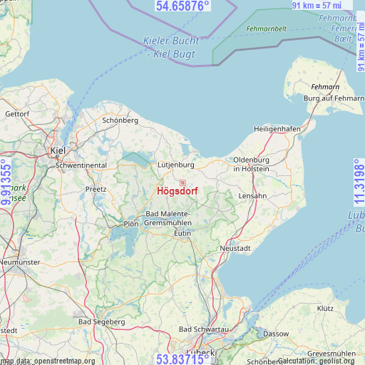
Högsdorf GPS coordinates[2]
54° 15' 0" North, 10° 37' 0.012" East
| Map corner | latitude | longitude |
|---|---|---|
| Upper-left | 54.65876°, | 9.91355° |
| Center: | 54.25°, | 10.61667° |
| Lower-right: | 53.83715°, | 11.3198° |
| Map W x H: | 91.4×91.4 km | = 56.8×56.8mi |
| max Lat: | 55.01917° ⇑4.3% North |
| Högsdorf: | 54.25° |
| min Lat: | ⇓95.7% South 47.40724° |
| min Long | Högsdorf | max Long |
| 5.92978° | 10.61667° | 14.98853° |
| W 61.1%⇐ | ⇒38.9% E |
Elevation
Elevation of Högsdorf is 57 m = 187 ft, and this is 192.1 m = 630 ft below average elevation for this country.
| Max E: |
1256 m = 4121 ft | 76.7% |
| Avg. | 249.1 m = 817 ft | |
| Högsdorf | 57 m = 187 ft | |
Min E: |
-5 m = -16 ft | 23.3% |
See also: Germany elevation on elevation.city.
Geographical zone
Högsdorf is located in North temperate zone (between Tropic of Cancer and the Arctic Circle). Distance of this North polar circle is 1369.1 km =850.7 mi to North.| Distance of | km | miles | from Högsdorf |
|---|---|---|---|
| North Pole | 3975 | 2469.9 | to North |
| Arctic Circle | 1369.1 | 850.7 | to North |
| Tropic Cancer | 3426.1 | 2128.9 | to South |
| Equator | 6032 | 3748.1 | to South |


Nearby cities:
15 places around Högsdorf: (largest is in red/bold)
• Blekendorf
4.5 km =2.8 mi,  37°
37°
• Dannau
4.9 km =3 mi,  257°
257°
• Giekau
9.9 km =6.2 mi,  318°
318°
• Grebin
9.4 km =5.8 mi,  233°
233°
• Helmstorf
3.9 km =2.4 mi,  343°
343°
• Hohwacht
8.6 km =5.3 mi,  23°
23°
• Kirchnüchel
7 km =4.3 mi,  142°
142°
• Klamp
7.8 km =4.8 mi, 315°
• Kletkamp
1.1 km =0.7 mi,  90°
90°
• Lütjenburg
5 km =3.1 mi, 339°
• Malente
9.4 km =5.8 mi,  203°
203°
• Neukirchen
5.7 km =3.5 mi, 226°
• Panker
9.8 km =6.1 mi, 340°
• Rantzau
6.5 km =4 mi,  270°
270°
• Wangels
9.9 km =6.2 mi,  79°
79°
Sources, notices
• [Note1] Compared only with cities in Germany existing in our database
• [Src1] Map data: © OpenStreetMap contributors (CC-BY-SA)
• [Src2] Other city data from geonames.org with taken over terms of usage.
• [Src3] Geographical zone / Annual Mean Temperature by Robert A. Rohde @ Wikipedia
