Dettenhausen geodata
Dettenhausen (Baden-Württemberg) is a seat of a fourth-order administrative division; located in Germany in Europe/Berlin (GMT+2) time zone. With population of 5,390 people, there are 2667 cities with bigger population in this country. Compared to other cities in Germany, 87.7% of cities are located further ↑North; 64% of cities are located further →East and 74.7% of cities have lower elevation than Dettenhausen. Note1
Administrative division(s):
- Level 1: Baden-Württemberg
- Level 2: Tübingen Region
- Level 3: Landkreis Tübingen
- Level 4: Dettenhausen


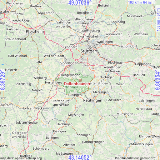
Dettenhausen GPS coordinates[2]
48° 36' 27.288" North, 9° 6' 1.476" East
| Map corner | latitude | longitude |
|---|---|---|
| Upper-left | 49.07036°, | 8.39729° |
| Center: | 48.60758°, | 9.10041° |
| Lower-right: | 48.14052°, | 9.80354° |
| Map W x H: | 103.4×103.4 km | = 64.2×64.2mi |
| max Lat: | 55.01917° ⇑87.7% North |
| Dettenhausen: | 48.60758° |
| min Lat: | ⇓12.3% South 47.40724° |
| min Long | Dettenhausen | max Long |
| 5.92978° | 9.10041° | 14.98853° |
| W 36%⇐ | ⇒64% E |
Elevation
Elevation of Dettenhausen is 395 m = 1296 ft, and this is 145.9 m = 479 ft above average elevation for this country.
| Max E: |
1256 m = 4121 ft | 25.3% |
| Dettenhausen | 395 m 1296 ft | |
| Avg. | 249.1 m = 817 ft | |
Min E: |
-5 m = -16 ft | 74.7% |
See also: Germany elevation on elevation.city.
Geographical zone
Dettenhausen is located in North temperate zone (between Tropic of Cancer and the Arctic Circle). Distance of this North polar circle is 1996.5 km =1240.6 mi to North.| Distance of | km | miles | from Dettenhausen |
|---|---|---|---|
| North Pole | 4602.4 | 2859.8 | to North |
| Arctic Circle | 1996.5 | 1240.6 | to North |
| Tropic Cancer | 2798.7 | 1739 | to South |
| Equator | 5404.7 | 3358.3 | to South |


Nearby cities:
15 places around Dettenhausen: (largest is in red/bold)
• Altdorf
8.1 km =5 mi,  288°
288°
• Altenriet
9.1 km =5.7 mi,  101°
101°
• Hildrizhausen
10 km =6.2 mi,  280°
280°
• Holzgerlingen
7.4 km =4.6 mi,  298°
298°
• Kirchentellinsfurt
9 km =5.6 mi,  157°
157°
• Kusterdingen
9.5 km =5.9 mi,  171°
171°
• Neckartenzlingen
10.1 km =6.3 mi, 101°
• Pliezhausen
9.5 km =5.9 mi,  124°
124°
• Schlaitdorf
9 km =5.6 mi,  92°
92°
• Schönaich
6.4 km =4 mi,  332°
332°
• Sickenhausen
10.2 km =6.3 mi,  144°
144°
• Steinenbronn
6.7 km =4.2 mi,  10°
10°
• Tübingen
10.1 km =6.3 mi,  200°
200°
• Waldenbuch
4.2 km =2.6 mi,  34°
34°
• Weil im Schönbuch
3.2 km =2 mi, 301°
Sources, notices
• [Note1] Compared only with cities in Germany existing in our database
• [Src1] Map data: © OpenStreetMap contributors (CC-BY-SA)
• [Src2] Other city data from geonames.org with taken over terms of usage.
• [Src3] Geographical zone / Annual Mean Temperature by Robert A. Rohde @ Wikipedia
