Straelen geodata
Straelen (North Rhine-Westphalia) is a populated place; located in Germany in Europe/Berlin (GMT+2) time zone. With population of 15,325 people, there are 1041 cities with bigger population in this country. Compared to other cities in Germany, 65.4% of cities are located further ↓South; 99.4% of cities are located further →East and 80.2% of cities have higher elevation than Straelen. Note1
Administrative division(s):
- Level 1: North Rhine-Westphalia
- Level 2: Düsseldorf District
- Level 3: Kreis Kleve
- Level 4: Straelen


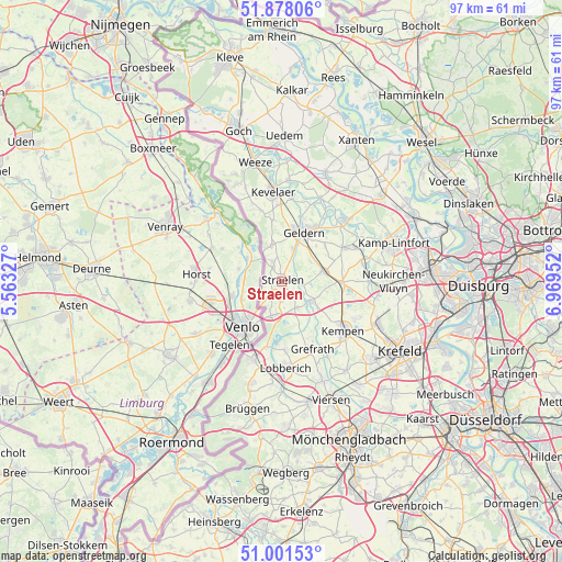
Straelen GPS coordinates[2]
51° 26' 30.84" North, 6° 15' 59.004" East
| Map corner | latitude | longitude |
|---|---|---|
| Upper-left | 51.87806°, | 5.56327° |
| Center: | 51.4419°, | 6.26639° |
| Lower-right: | 51.00153°, | 6.96952° |
| Map W x H: | 97.5×97.5 km | = 60.6×60.6mi |
| max Lat: | 55.01917° ⇑34.6% North |
| Straelen: | 51.4419° |
| min Lat: | ⇓65.4% South 47.40724° |
| min Long | Straelen | max Long |
| 5.92978° | 6.26639° | 14.98853° |
| W 0.6%⇐ | ⇒99.4% E |
Elevation
Elevation of Straelen is 46 m = 151 ft, and this is 203.1 m = 666 ft below average elevation for this country.
| Max E: |
1256 m = 4121 ft | 80.2% |
| Avg. | 249.1 m = 817 ft | |
| Straelen | 46 m = 151 ft | |
Min E: |
-5 m = -16 ft | 19.8% |
See also: Germany elevation on elevation.city.
Geographical zone
Straelen is located in North temperate zone (between Tropic of Cancer and the Arctic Circle). Distance of this North polar circle is 1681.4 km =1044.8 mi to North.| Distance of | km | miles | from Straelen |
|---|---|---|---|
| North Pole | 4287.3 | 2664 | to North |
| Arctic Circle | 1681.4 | 1044.8 | to North |
| Tropic Cancer | 3113.9 | 1934.9 | to South |
| Equator | 5719.8 | 3554.1 | to South |


Nearby cities:
15 places around Straelen: (largest is in red/bold)
• Geldern
9.5 km =5.9 mi,  24°
24°
• Grefrath
12.8 km =8 mi,  156°
156°
• Issum
15.4 km =9.6 mi,  48°
48°
• Kamp-Lintfort
20.6 km =12.8 mi,  70°
70°
• Kempen
13.6 km =8.5 mi,  129°
129°
• Kevelaer
15.7 km =9.8 mi,  354°
354°
• Krefeld
23.1 km =14.4 mi,  120°
120°
• Nettetal
14 km =8.7 mi,  175°
175°
• Rheurdt
14.1 km =8.8 mi,  78°
78°
• Sonsbeck
20 km =12.4 mi, 22°
• Tönisvorst
20.8 km =12.9 mi, 130°
• Viersen
22.7 km =14.1 mi, 156°
• Wachtendonk
6.2 km =3.9 mi, 125°
• Weeze
21.1 km =13.1 mi, 347°
• Wemb
17.2 km =10.7 mi,  338°
338°
Sources, notices
• [Note1] Compared only with cities in Germany existing in our database
• [Src1] Map data: © OpenStreetMap contributors (CC-BY-SA)
• [Src2] Other city data from geonames.org with taken over terms of usage.
• [Src3] Geographical zone / Annual Mean Temperature by Robert A. Rohde @ Wikipedia
