Thüngersheim geodata
Thüngersheim (Bavaria) is a seat of a fourth-order administrative division; located in Germany in Europe/Berlin (GMT+2) time zone. With population of 2,726 people, there are 4213 cities with bigger population in this country. Compared to other cities in Germany, 67% of cities are located further ↑North; 52.2% of cities are located further →East and 54.9% of cities have higher elevation than Thüngersheim. Note1
Administrative division(s):
- Level 1: Bavaria
- Level 2: Regierungsbezirk Unterfranken
- Level 3: Landkreis Würzburg
- Level 4: Thüngersheim


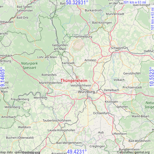
Thüngersheim GPS coordinates[2]
49° 52' 41.988" North, 9° 50' 57.012" East
| Map corner | latitude | longitude |
|---|---|---|
| Upper-left | 50.32931°, | 9.14605° |
| Center: | 49.87833°, | 9.84917° |
| Lower-right: | 49.4231°, | 10.5523° |
| Map W x H: | 100.8×100.8 km | = 62.6×62.6mi |
| max Lat: | 55.01917° ⇑67% North |
| Thüngersheim: | 49.87833° |
| min Lat: | ⇓33% South 47.40724° |
| min Long | Thüngersheim | max Long |
| 5.92978° | 9.84917° | 14.98853° |
| W 47.8%⇐ | ⇒52.2% E |
Elevation
Elevation of Thüngersheim is 190 m = 623 ft, and this is 59.1 m = 194 ft below average elevation for this country.
| Max E: |
1256 m = 4121 ft | 54.9% |
| Avg. | 249.1 m = 817 ft | |
| Thüngersheim | 190 m = 623 ft | |
Min E: |
-5 m = -16 ft | 45.1% |
See also: Germany elevation on elevation.city.
Geographical zone
Thüngersheim is located in North temperate zone (between Tropic of Cancer and the Arctic Circle). Distance of this North polar circle is 1855.2 km =1152.8 mi to North.| Distance of | km | miles | from Thüngersheim |
|---|---|---|---|
| North Pole | 4461.1 | 2772 | to North |
| Arctic Circle | 1855.2 | 1152.8 | to North |
| Tropic Cancer | 2940 | 1826.8 | to South |
| Equator | 5546 | 3446.1 | to South |


Nearby cities:
15 places around Thüngersheim: (largest is in red/bold)
• Erlabrunn
2.1 km =1.3 mi,  189°
189°
• Gadheim
5.4 km =3.4 mi,  131°
131°
• Greußenheim
9.1 km =5.7 mi,  220°
220°
• Güntersleben
4.1 km =2.5 mi,  103°
103°
• Hettstadt
9.1 km =5.7 mi,  195°
195°
• Himmelstadt
6.1 km =3.8 mi,  326°
326°
• Karlstadt
10.6 km =6.6 mi, 328°
• Margetshöchheim
4.7 km =2.9 mi,  166°
166°
• Retzstadt
4.5 km =2.8 mi,  31°
31°
• Rimpar
8.1 km =5 mi,  107°
107°
• Thüngen
7 km =4.3 mi,  5°
5°
• Veitshöchheim
5.6 km =3.5 mi,  155°
155°
• Waldbüttelbrunn
10 km =6.2 mi,  181°
181°
• Zell am Main
7.5 km =4.7 mi, 168°
• Zellingen
3.1 km =1.9 mi,  312°
312°
Sources, notices
• [Note1] Compared only with cities in Germany existing in our database
• [Src1] Map data: © OpenStreetMap contributors (CC-BY-SA)
• [Src2] Other city data from geonames.org with taken over terms of usage.
• [Src3] Geographical zone / Annual Mean Temperature by Robert A. Rohde @ Wikipedia
